File:Ottoman Empire 1500-1700.jpg

Original file (960 × 1,057 pixels, file size: 448 KB, MIME type: image/jpeg)
Captions
Captions

|
This map image could be re-created using vector graphics as an SVG file. This has several advantages; see Commons:Media for cleanup for more information. If an SVG form of this image is available, please upload it and afterwards replace this template with
{{vector version available|new image name}}.
It is recommended to name the SVG file “Ottoman Empire 1500-1700.svg”—then the template Vector version available (or Vva) does not need the new image name parameter. |

Summary
edit
| Description |
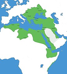
English: Extent of Ottoman suzerainty 1500-1700 List of sources Oman “1552 Ottoman fleet under command of Piri Reis attacks Muscat and captures the town and the forts before departing.” Historical Muscat: An Illustrated Guide and GazetteerJohn PetersonBRILL, 2007 “However, before they could act, the Ottomans captured Muscat” Routledge Handbook of Persian Gulf PoliticsMehran KamravaRoutledge, 31 May 2020 “In 1659 the Ottoman Empire took possession.” “1659 , when the Ottoman Empire replaced it as a leading regional force . The Turks ruled Oman until 1741.” A Historical Atlas of OmanMichael IssacThe Rosen Publishing Group, Inc, 15 Dec 2003 Ukraine, Podolia, Cossack Hetmanate “The Ottomans continued to recognize some use for the Cossack vassal state and appointed Iurii Khmelnytsky as hetman” “Finally, after defeating Poland in 1672, the Ottomans annexed a huge swath of territory in Right Bank Ukraine (Podolia, Bratslav, and southern Kiev palatinates). Meanwhile, Doroshenko scrambled wildly, changing his allegiance several times among Poland, the Ottoman Empire” Maps Morocco, Wattasid Sultanate “while Muhammad al-Shaykh resumed the struggle against the Wattasid. The latter thereupon sought aid from the Turks, who were by now firmly established in Algiers, and declared himself a vassal of the Ottoman Sultan.” The Muslim World: The last great Muslim empiresBertold SpulerE. J. Brill, 1969 “the Wattasid ruler, Abu Hasun, sent a message of submission to the far-off sultan of the Ottoman Empire” Ahmad Al-Mansur: Islamic VisionaryRichard Lee SmithPearson Longman, 2006 “Ali Abu Hassun then ruled on behalf of Ahmad’s young son Nasir al-Qasiri and formally acknowledged the Ottoman sultan’s authority” “And such “vassal” status has been attributed to both Muslim and Christian polities-Fez (Morocco)” Maps African states in the 15th – 17th centuriesDiercke International Atlas Attila Sendromu: Batı Hıristiyanlığının ŞuurötesiBy Fevzi Samuk Adal Sultanate “In return, Ahmed Grañ agreed to formally recognise Ottoman suzerainty, pay 100,000 okkas of gold annually to the Ottoman governor” The Ottoman Age of ExplorationGiancarlo CasaleOxford University Press, 25 Feb 2010 Swahili coast “fleets under Mir Ali Bey were easily able to force most of the coastal cities between Mogadishu and Kilwa to accept Ottoman suzerainty” “succeeded in establishing Ottoman suzerainty on the East African coast from Mogadishu down to Mombasa” “of Mir 'Ali Bey, who persuaded most of the cities of the Swahili coast between Mogadishu and Kilwa to recognize Ottoman supremacy” Eritrea, Djibouti, Red Sea coast “The largely coastal territory west of the Red Sea, between Djibouti and Sudan, came under Turkish imperial rule following the conquests of Suleiman I” The Battle of Adwa: African Victory in the Age of EmpireRaymond JonasHarvard University Press, “extended from the southern border of Egypt all the way to the Horn of Africa, encompassing most of present-day Sudan, Djibouti on the horn of Africa, and coastal Ethiopia” Daily Life in the Ottoman EmpireMehrdad KiaABC-CLIO, 17 Aug 2011 “After 1557 the coastal plain of Eritrea became part of the expanding Ottoman Empire” Libyan desert “Chadic state continued to exercise some authority over Fezzan until 1574 when the Ottoman Turks invaded Fezzan and occupied the oasis” “the extension of Turkish control to Ghat , Murzuq and Ghadames in the mid sixteenth century” Arabian Peninsula (shaded area) “Arabia remained unsettled until the beginning of the 16th century , when the whole peninsula came under the nominal rule of the Ottoman Sultans” The Middle East and North Africa 2003By Eur “The entire Arabian Peninsula was regarded as Ottoman imperial territory” Mubarak Al-Sabah: Founder of Modern Kuwait 1896-1915B. SlotArabian, 2005 “At the beginning of the 16th century the whole peninsula came nominally under the suzerainty of the Ottoman Sultan” The Read Sea and the Gulf of AdenRuth LapidothMartinus Nijhoff Publishers, 1982 “The whole of the Arabian Peninsula became part of Turkey's Ottoman Empire in the 16h century” Maps Turcici Imperii Descriptio, Antwerp c. 1570ORTELIUS, Abraham Turcici Imperii Imago, Amsterdam c. 1606HONDIUS, Jodocus The Turkish Empire, London c. 1627SPEED, John |
| Date | |
| Source | Own work |
| Author | Trap24 |
Licensing
edit
- You are free:
- to share – to copy, distribute and transmit the work
- to remix – to adapt the work
- Under the following conditions:
- attribution – You must give appropriate credit, provide a link to the license, and indicate if changes were made. You may do so in any reasonable manner, but not in any way that suggests the licensor endorses you or your use.
- share alike – If you remix, transform, or build upon the material, you must distribute your contributions under the same or compatible license as the original.
File history
Click on a date/time to view the file as it appeared at that time.
| Date/Time | Thumbnail | Dimensions | User | Comment | |
|---|---|---|---|---|---|
| current | 18:30, 30 November 2021 | | 960 × 1,057 (448 KB) | Trap24 (talk | contribs) | Uploaded own work with UploadWizard |
You cannot overwrite this file.
File usage on Commons
There are no pages that use this file.