File:Outer Photographers and Torch Reefs Map.png

Size of this preview: 614 × 599 pixels. Other resolutions: 246 × 240 pixels | 492 × 480 pixels | 787 × 768 pixels | 1,050 × 1,024 pixels | 2,099 × 2,048 pixels | 7,800 × 7,610 pixels.
Original file (7,800 × 7,610 pixels, file size: 3.06 MB, MIME type: image/png)
Captions
Captions
Add a one-line explanation of what this file represents
Summary
edit
| Description |
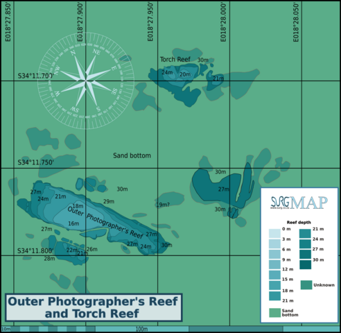
English: Map of the dive sites Outer Photographer's Reef and Torch Reef, Cape Peninsula. |
| Date | |
| Source | Peter Southwood |
| Author | Peter Southwood |
Licensing
edit
Pbsouthwood, the copyright holder of this work, hereby publishes it under the following license:
This file is licensed under the Creative Commons Attribution-Share Alike 3.0 Unported license.
Attribution: Pbsouthwood
- You are free:
- to share – to copy, distribute and transmit the work
- to remix – to adapt the work
- Under the following conditions:
- attribution – You must give appropriate credit, provide a link to the license, and indicate if changes were made. You may do so in any reasonable manner, but not in any way that suggests the licensor endorses you or your use.
- share alike – If you remix, transform, or build upon the material, you must distribute your contributions under the same or compatible license as the original.
Original upload log
edit
| This file was imported from Wikivoyage WTS. |
The original description page was here. All following user names refer to wts.wikivoyage-old.
org:
- 2011-05-19 07:06 (WT-shared) Pbsouthwood[dead link] 1600×1831 (267296 bytes) {{Imagecredit|credit=Peter Southwood|captureDate=May 2011|location=Cape Peninsula|source=Peter Southwood|caption=Map of the dive sites Outer (Import from wikitravel.org/shared)
- 2011-05-19 07:46 (WT-shared) Pbsouthwood[dead link] 1600×1870 (416656 bytes) Depth colour correction, added scale bar (Import from wikitravel.org/shared)
- 2011-06-07 10:02 (WT-shared) Pbsouthwood[dead link] 1917×1870 (506139 bytes) additional reef, compass rose. (Import from wikitravel.org/shared)
- 2012-09-10 08:17 Pbsouthwood[dead link] 3000×2927 (858577 bytes) rm logo
File history
Click on a date/time to view the file as it appeared at that time.
| Date/Time | Thumbnail | Dimensions | User | Comment | |
|---|---|---|---|---|---|
| current | 11:41, 8 July 2024 | | 7,800 × 7,610 (3.06 MB) | Pbsouthwood (talk | contribs) | Added perimeter of NE outlier |
| 10:50, 29 January 2024 |  | 7,800 × 7,610 (2.98 MB) | Pbsouthwood (talk | contribs) | perimeter and contour at south outlier | |
| 09:42, 21 November 2022 |  | 7,800 × 7,610 (2.89 MB) | Pbsouthwood (talk | contribs) | finished 27m contour at Outer Photographers | |
| 09:26, 18 October 2020 |  | 7,800 × 7,610 (2.79 MB) | Pbsouthwood (talk | contribs) | 21 and 27m contours at Outer Photographers, other tweaks | |
| 17:21, 30 December 2018 |  | 7,800 × 7,610 (2.7 MB) | Pbsouthwood (talk | contribs) | Added 21m and 24m contours at Torch Reef | |
| 19:48, 12 September 2016 |  | 7,794 × 7,605 (2.58 MB) | Pbsouthwood (talk | contribs) | add outliers and 18m contour | |
| 16:17, 23 December 2012 |  | 3,000 × 2,927 (838 KB) | OgreBot (talk | contribs) | (BOT): Reverting to most recent version before archival | |
| 16:17, 23 December 2012 |  | 1,917 × 1,870 (494 KB) | OgreBot (talk | contribs) | (BOT): Uploading old version of file from wts.wikivoyage; originally uploaded on 2011-06-07 10:02:33 by (WT-shared) Pbsouthwood | |
| 16:17, 23 December 2012 |  | 1,600 × 1,870 (407 KB) | OgreBot (talk | contribs) | (BOT): Uploading old version of file from wts.wikivoyage; originally uploaded on 2011-05-19 07:46:45 by (WT-shared) Pbsouthwood | |
| 16:16, 23 December 2012 |  | 1,600 × 1,831 (261 KB) | OgreBot (talk | contribs) | (BOT): Uploading old version of file from wts.wikivoyage; originally uploaded on 2011-05-19 07:06:29 by (WT-shared) Pbsouthwood |
You cannot overwrite this file.
File usage on Commons
The following 10 pages use this file:
- User:Chumwa/OgreBot/Transport Maps/2020 October 11-20
- User:Chumwa/OgreBot/Transport Maps/2022 November 21-30
- User:Chumwa/OgreBot/Transport Maps/2024 January 21-31
- User:Chumwa/OgreBot/Transport Maps/2024 July 1-10
- User:Chumwa/OgreBot/Travel and communication maps/2016 September 11-20
- User:Chumwa/OgreBot/Travel and communication maps/2018 December 21-31
- User:Chumwa/OgreBot/Travel and communication maps/2020 October 11-20
- User:Chumwa/OgreBot/Travel and communication maps/2022 November 21-30
- User:Chumwa/OgreBot/Travel and communication maps/2024 January 21-31
- User:Chumwa/OgreBot/Travel and communication maps/2024 July 1-10
File usage on other wikis
The following other wikis use this file:
- Usage on en.wikivoyage.org
- Usage on www.wikidata.org