File:Outfall of the Severn Tunnel Great Spring, Sudbrook - geograph.org.uk - 157922.jpg
No higher resolution available.
Outfall_of_the_Severn_Tunnel_Great_Spring,_Sudbrook_-_geograph.org.uk_-_157922.jpg (627 × 414 pixels, file size: 131 KB, MIME type: image/jpeg)
Captions
Captions
Add a one-line explanation of what this file represents
Summary
edit
| Description |
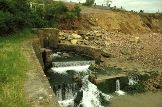
English: Outfall of the Severn Tunnel Great Spring, Sudbrook On 16th October 1879 engineers driving the Severn Tunnel struck a water-filled passage 170 feet underground and 400 yards inland. The tunnel was flooded within 2 days and took 2 years to finally drain. Ever since the tunnel has been kept dry by pumping more than 23 million gallons of fresh water a day to the surface. This exceptionally pure water is used by a paper mill and brewery; what is left emerges at this outfall. |
| Date | |
| Source | From geograph.org.uk |
| Author | Mike Simms |
| Attribution (required by the license) | Mike Simms / Outfall of the Severn Tunnel Great Spring, Sudbrook / |
| Object location | | View this and other nearby images on: OpenStreetMap |
|---|
_&language=en)
Licensing
edit

|
This image was taken from the Geograph project collection. See this photograph's page on the Geograph website for the photographer's contact details. The copyright on this image is owned by Mike Simms and is licensed for reuse under the Creative Commons Attribution-ShareAlike 2.0 license.
|
This file is licensed under the Creative Commons Attribution-Share Alike 2.0 Generic license.
Attribution: Mike Simms
- You are free:
- to share – to copy, distribute and transmit the work
- to remix – to adapt the work
- Under the following conditions:
- attribution – You must give appropriate credit, provide a link to the license, and indicate if changes were made. You may do so in any reasonable manner, but not in any way that suggests the licensor endorses you or your use.
- share alike – If you remix, transform, or build upon the material, you must distribute your contributions under the same or compatible license as the original.
File history
Click on a date/time to view the file as it appeared at that time.
| Date/Time | Thumbnail | Dimensions | User | Comment | |
|---|---|---|---|---|---|
| current | 10:06, 31 January 2010 | | 627 × 414 (131 KB) | GeographBot (talk | contribs) | == {{int:filedesc}} == {{Information |description={{en|1=Outfall of the Severn Tunnel Great Spring, Sudbrook On 16th October 1879 engineers driving the Severn Tunnel struck a water-filled passage 170 feet underground and 400 yards inland. The tunnel was f |
You cannot overwrite this file.
File usage on Commons
There are no pages that use this file.