File:Outflow bndry.png

Size of this preview: 318 × 598 pixels. Other resolutions: 127 × 240 pixels | 255 × 480 pixels | 408 × 768 pixels | 1,236 × 2,325 pixels.
Original file (1,236 × 2,325 pixels, file size: 1.3 MB, MIME type: image/png)
Captions
Captions
Add a one-line explanation of what this file represents
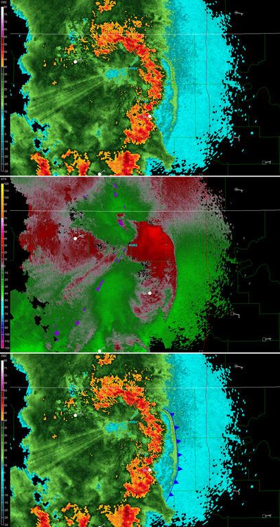
| Description | Composite radar image of an outflow boundary coming from a Thunderstorm. Upper image shows strong reflectivities in the thunderstorms (Red) while a weaker line of echoes (Light green in the cyan area to the right) indicate the convection generated by the gust front. In the centre, the Doppler velocities relative to the radar shows a zone of convergence (red away from radar and green towards it) on the outer edge of the weak line of echoes. At the bottom, the outflow boundary is indicated on the reflectivity image as a cold front line. |
| Date | (UTC) |
| Source | Created by Vaughan Weather using free NWS level 2 NEXRAD data |
| Author | Theonlysilentbob |
| Other versions | en:Image:Outflow bndry.png |
Theonlysilentbob at the English-language Wikipedia, the copyright holder of this work, hereby publishes it under the following license:

|
Permission is granted to copy, distribute and/or modify this document under the terms of the GNU Free Documentation License, Version 1.2 or any later version published by the Free Software Foundation; with no Invariant Sections, no Front-Cover Texts, and no Back-Cover Texts. A copy of the license is included in the section entitled GNU Free Documentation License. |
| This file is licensed under the Creative Commons Attribution-Share Alike 3.0 Unported license. | ||
| Attribution: Theonlysilentbob | ||
| ||
| This licensing tag was added to this file as part of the GFDL licensing update. |
File history
Click on a date/time to view the file as it appeared at that time.
| Date/Time | Thumbnail | Dimensions | User | Comment | |
|---|---|---|---|---|---|
| current | 00:45, 18 October 2007 | | 1,236 × 2,325 (1.3 MB) | Pierre cb (talk | contribs) | {{Information |Description=Coposite radar image of an outflow boundary coming from a Thumderstorm. Upper image shows strong reflectivities in the thunderstorms (Red) while a weaker line of echoes (Light green in the cyan area to the right) indicate the co |
You cannot overwrite this file.
File usage on Commons
The following page uses this file:
File usage on other wikis
The following other wikis use this file:
- Usage on ca.wikipedia.org
- Usage on en.wikipedia.org
- Usage on es.wikipedia.org
- Usage on fr.wikipedia.org
- Usage on nn.wikipedia.org