File:Outline Map of Tatarstan (with position on the map of Russia).svg

Size of this PNG preview of this SVG file: 800 × 541 pixels. Other resolutions: 320 × 216 pixels | 640 × 433 pixels | 1,024 × 693 pixels | 1,280 × 866 pixels | 2,560 × 1,732 pixels | 2,491 × 1,685 pixels.
Original file (SVG file, nominally 2,491 × 1,685 pixels, file size: 673 KB)
Captions
Captions
Add a one-line explanation of what this file represents
| Description |
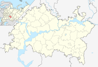
Русский: Позиционная карта Республики Татарстан, с локатором на карте России Равноугольная проекция, растяжение - 175%. Координаты краёв: * север - 56.8° С * юг - 53.9° С * восток - 54.5° В * запад - 47.0° В |
| Date | (UTC) |
| Source | |
| Author | |
| Other versions |
[]
|


.svg)
.svg)
| This is a retouched picture, which means that it has been digitally altered from its original version. Modifications: Объединил карты. The original can be viewed here: Map of Russia - Republic of Tatarstan (2008-03).svg:
|
This file is licensed under the Creative Commons Attribution-Share Alike 3.0 Unported license.
- You are free:
- to share – to copy, distribute and transmit the work
- to remix – to adapt the work
- Under the following conditions:
- attribution – You must give appropriate credit, provide a link to the license, and indicate if changes were made. You may do so in any reasonable manner, but not in any way that suggests the licensor endorses you or your use.
- share alike – If you remix, transform, or build upon the material, you must distribute your contributions under the same or compatible license as the original.
Original upload log edit
.svg&action=edit§ion=1)
This image is a derivative work of the following images:
- File:Outline_Map_of_Tatarstan.svg licensed with PD-self
- 2010-02-19T18:27:02Z Виктор В 2491x1685 (479266 Bytes) ошибся
- 2010-02-19T18:25:48Z Виктор В 2491x1685 (479593 Bytes) множественные мелкие правки
- 2010-02-18T18:33:54Z Виктор В 2491x1685 (350202 Bytes) == {{int:filedesc}} == {{Information |Description={{ru|1=Позиционная карта Республики ТатарстанРавноугольная проекция, растяжение - 175%. Координаты
- File:Map_of_Russia_-_Republic_of_Tatarstan_(2008-03).svg licensed with Cc-by-sa-2.5
- 2010-02-04T16:58:29Z Виктор В 1092x630 (213460 Bytes) new color
- 2008-01-27T18:20:29Z Marmelad 1092x630 (227714 Bytes) {{Information |Description=Autogenerated image to indicate Russian subjects as of 2008-03. Subject as indicated by filename. |Source=Made from [[:Image:Map of Russian subjects, 2008-03-01.svg]] |Date=2008-01-27 |Author=[[User
Uploaded with derivativeFX
File history
Click on a date/time to view the file as it appeared at that time.
| Date/Time | Thumbnail | Dimensions | User | Comment | |
|---|---|---|---|---|---|
| current | 19:12, 19 February 2010 | | 2,491 × 1,685 (673 KB) | Виктор В (talk | contribs) | {{Information |Description={{ru|1=Позиционная карта Республики Татарстан, с локатором на карте России<br>Равноугольная проекция, растяжение - 175%. Координат |
You cannot overwrite this file.
File usage on Commons
The following 5 pages use this file:
File usage on other wikis
The following other wikis use this file:
- Usage on en.wikipedia.org
- Usage on fa.wikipedia.org
- Usage on id.wikipedia.org
- Usage on pnb.wikipedia.org
- Usage on pt.wikipedia.org
- Usage on tr.wikipedia.org
.svg&oldid=469729424)