File:Overhead power line poles, Rhee Wall - geograph.org.uk - 394159.jpg

Size of this preview: 449 × 600 pixels. Other resolutions: 179 × 240 pixels | 479 × 640 pixels.
Original file (479 × 640 pixels, file size: 136 KB, MIME type: image/jpeg)
Captions
Captions
Add a one-line explanation of what this file represents
Summary
edit
| Description |
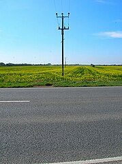
English: Overhead power line poles, Rhee Wall. Emphasising the flatness of the terrain. The road is the A259 which runs along the course of the Rhee Wall from Brenzett to New Romney. The wall was actually a medieval watercourse built in an attempt to save the port of New Romney from silting up. By operating three sluices it collected tidal water from Appledore then released it into the channel at New Romney to scour the inlet. Nature defeated medieval ingenuity and the watercourse had been abandoned by the 15th century, filled in and being embanked was used as a causeway through the marshes. |
| Date | |
| Source | From geograph.org.uk |
| Author | Simon Carey |
| Attribution (required by the license) | Simon Carey / Power Poles, Rhee Wall / |
| Camera location | | View this and other nearby images on: OpenStreetMap |
|---|
_heading:225.00&language=en)
| Object location | | View this and other nearby images on: OpenStreetMap |
|---|
_heading:225.00&language=en)
Licensing
edit

|
This image was taken from the Geograph project collection. See this photograph's page on the Geograph website for the photographer's contact details. The copyright on this image is owned by Simon Carey and is licensed for reuse under the Creative Commons Attribution-ShareAlike 2.0 license.
|
This file is licensed under the Creative Commons Attribution-Share Alike 2.0 Generic license.
Attribution: Simon Carey
- You are free:
- to share – to copy, distribute and transmit the work
- to remix – to adapt the work
- Under the following conditions:
- attribution – You must give appropriate credit, provide a link to the license, and indicate if changes were made. You may do so in any reasonable manner, but not in any way that suggests the licensor endorses you or your use.
- share alike – If you remix, transform, or build upon the material, you must distribute your contributions under the same or compatible license as the original.
File history
Click on a date/time to view the file as it appeared at that time.
| Date/Time | Thumbnail | Dimensions | User | Comment | |
|---|---|---|---|---|---|
| current | 19:17, 3 February 2011 | | 479 × 640 (136 KB) | GeographBot (talk | contribs) | == {{int:filedesc}} == {{Information |description={{en|1=Telephone Poles, Rhee Wall Emphasising the flatness of the terrain. The road is the A259 which runs along the course of the Rhee Wall from Brenzett to New Romney. The wall was actually a medieval wa |
You cannot overwrite this file.
File usage on Commons
The following page uses this file:
- File:Telephone Poles, Rhee Wall - geograph.org.uk - 394159.jpg (file redirect)