File:Overview2008-HEI-no.PNG

Size of this preview: 641 × 599 pixels. Other resolutions: 257 × 240 pixels | 514 × 480 pixels | 888 × 830 pixels.
Original file (888 × 830 pixels, file size: 51 KB, MIME type: image/png)
File information
Structured data
Captions
Captions
Add a one-line explanation of what this file represents
Summary
edit| DescriptionOverview2008-HEI-no.PNG |
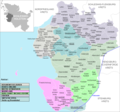
English: A Norwegian version of the overview map made by Geograv. The map is made to fit the new borders that will be set in 2008 Norsk bokmål: En norsk versjon av oversiktskartet lagd av Geograv som viser de ulike amtene og kommunene i Ditmarsken krets. Amtsinndelingen er den nyest oppdaterte, altså den av 1. januar og 25. mai 2008. |
|||
| Date | November 14th, 2007 – Updated at February 6th, 2008. | |||
| Source |
|
|||
| Author | Erik Fløan | |||
| Permission (Reusing this file) |
Public Domain. | |||
| Other versions |
|
Licensing
edit| Public domainPublic domainfalsefalse |
| I, the copyright holder of this work, release this work into the public domain. This applies worldwide. In some countries this may not be legally possible; if so: I grant anyone the right to use this work for any purpose, without any conditions, unless such conditions are required by law. |
File history
Click on a date/time to view the file as it appeared at that time.
| Date/Time | Thumbnail | Dimensions | User | Comment | |
|---|---|---|---|---|---|
| current | 18:58, 21 December 2008 |  | 888 × 830 (51 KB) | Efloean (talk | contribs) | {{Information |Description= {{en|A Norwegian version of the overview map made by ''Geograv''. The map is made to fit the new borders that will be set in 2008}} {{no|En norsk versjon av oversiktskartet lagd av Geograv som |
| 18:21, 6 February 2008 |  | 888 × 830 (51 KB) | Efloean (talk | contribs) | == Description == {{Information |Description= '''English:''' A Norwegian version of the overview map made by ''Geograv''. The map is made to fit the new borders that will be set in 2008.<br>'''Norsk (bokmål):''' En norsk versjon av overs | |
| 18:28, 7 January 2008 |  | 888 × 830 (51 KB) | Efloean (talk | contribs) | {{Information |Description= '''English:''' A Norwegian version of the overview map made by ''Geograv''. The map is made to fit the new borders that will be set in 2008.<br>'''Norsk (bokmål):''' En norsk versjon av oversiktskartet lagd av | |
| 23:53, 6 January 2008 |  | 888 × 830 (50 KB) | Efloean (talk | contribs) | == Beskrivelse == {{Information |Description= '''English:''' A Norwegian version of the overview map made by ''Geograv''. The map is made to fit the new borders that will be set in 2008.<br>'''Norsk (bokmål):''' En norsk versjon av overs | |
| 19:31, 14 November 2007 |  | 888 × 830 (51 KB) | Efloean (talk | contribs) | {{Information |Description=A Norwegian version of the overview map made by ''Geograv''. The map is made to fit the new borders that will be set in 2008. |Source=A German PD-map: Image:Uebersicht-HEI.png |Date=November 14th, 2007 |Aut |
You cannot overwrite this file.
File usage on Commons
There are no pages that use this file.
File usage on other wikis
The following other wikis use this file:
- Usage on no.wikipedia.org


