File:OzarkRelief.jpg
Size of this preview: 729 × 600 pixels. Other resolutions: 292 × 240 pixels | 584 × 480 pixels.
Original file (800 × 658 pixels, file size: 167 KB, MIME type: image/jpeg)
Captions
Captions
Add a one-line explanation of what this file represents
Summary
edit
| Description |
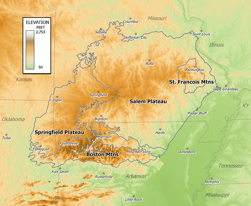
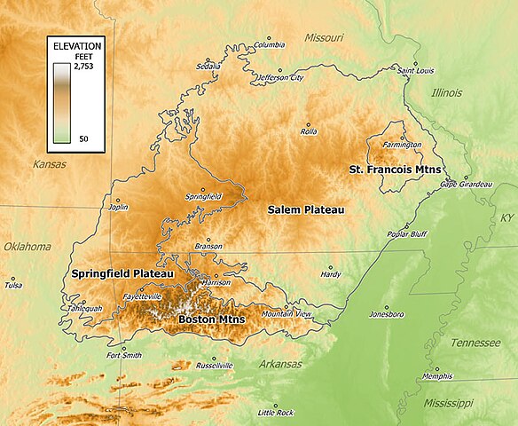
English: Relief map of en:the Ozarks. |
| Date | 31 December 2006 (original upload date) |
| Source | Transferred from en.wikipedia to Commons. |
| Author | Tosborn at English Wikipedia |
Licensing
edit
| This work has been released into the public domain by its author, Tosborn at English Wikipedia. This applies worldwide. In some countries this may not be legally possible; if so: Tosborn grants anyone the right to use this work for any purpose, without any conditions, unless such conditions are required by law. |
Original upload log
edit
The original description page was here. All following user names refer to en.wikipedia.
- 2007-01-02 20:48 Tosborn 800×658×8 (170723 bytes) Elevation relief map of the Ozarks based on SRTM 3 arc second DEM.
- 2006-12-31 02:21 Tosborn 800×658×8 (170692 bytes) Relief map of the Ozarks.
File history
Click on a date/time to view the file as it appeared at that time.
| Date/Time | Thumbnail | Dimensions | User | Comment | |
|---|---|---|---|---|---|
| current | 20:09, 8 July 2008 | | 800 × 658 (167 KB) | Jo Weber (talk | contribs) | {{Information |Description={{en|Relief map of en:the Ozarks.}} |Source=Transferred from [http://en.wikipedia.org en.wikipedia] |Date=2006-12-31 (first version); 2007-01-02 (last version) |Author=Original uploader was Tosborn at [ |
You cannot overwrite this file.
File usage on Commons
The following page uses this file:
File usage on other wikis
The following other wikis use this file:
- Usage on bg.wikipedia.org
- Usage on cs.wikipedia.org
- Usage on cy.wikipedia.org
- Usage on de.wikipedia.org
- Usage on en.wikipedia.org
- Usage on eo.wikipedia.org
- Usage on es.wikipedia.org
- Usage on frr.wikipedia.org
- Usage on fr.wikipedia.org
- Usage on fr.wiktionary.org
- Usage on it.wikipedia.org
- Usage on lt.wikipedia.org
- Usage on nl.wikipedia.org
- Usage on nn.wikipedia.org
- Usage on no.wikipedia.org
- Usage on ro.wikipedia.org
- Usage on ru.wikipedia.org
- Usage on simple.wikipedia.org
- Usage on sv.wikipedia.org
- Usage on uk.wikipedia.org
- Usage on zh.wikipedia.org