File:P11-LB-positiekaart2-gemlabels.png
Size of this preview: 287 × 598 pixels. Other resolutions: 115 × 240 pixels | 230 × 480 pixels | 777 × 1,620 pixels.
Original file (777 × 1,620 pixels, file size: 918 KB, MIME type: image/png)
Captions
Captions
Add a one-line explanation of what this file represents
Summary
edit
| Description |
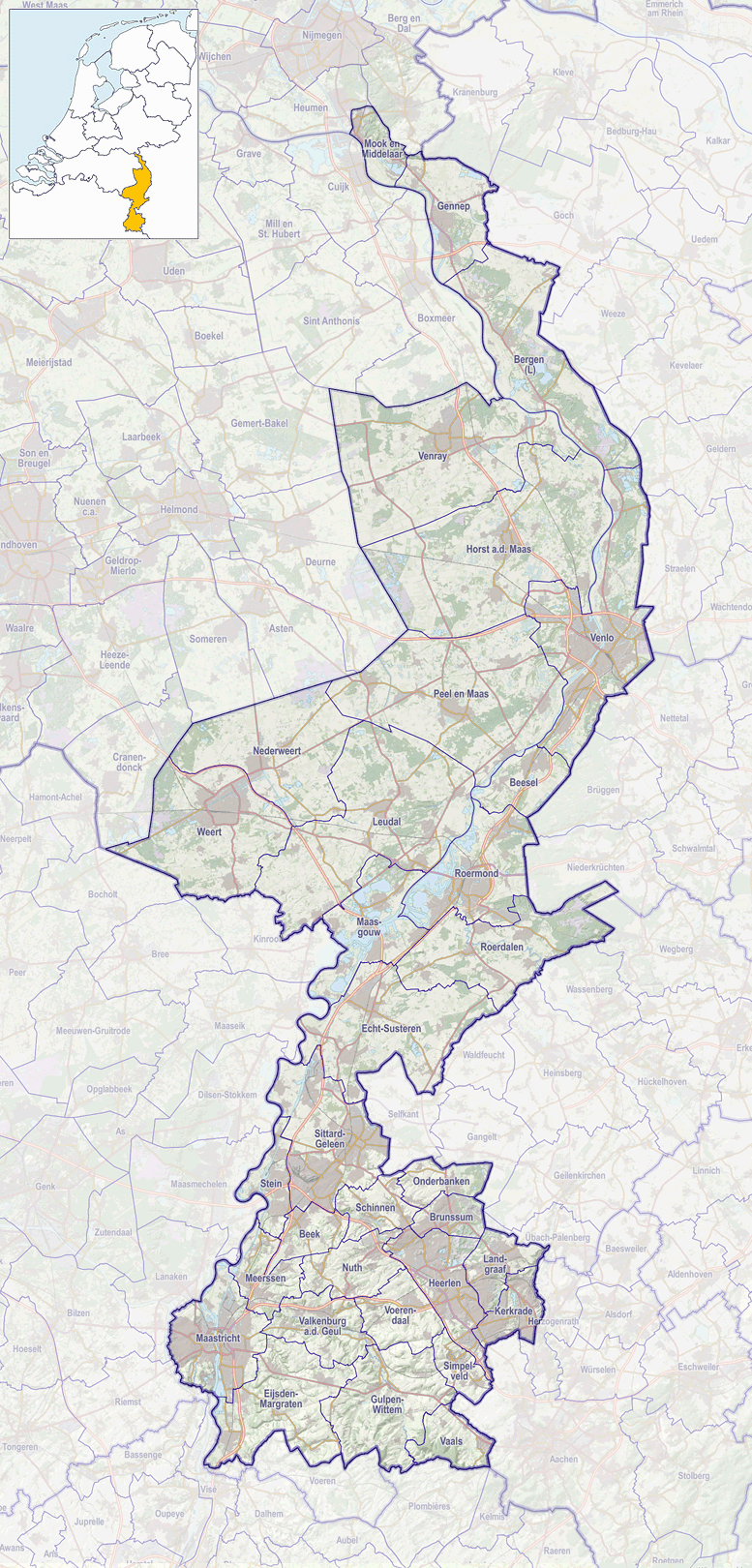
Nederlands: Positiekaartje van de provincie, variant "gemeentelabels" |
| Date | |
| Source | Own work |
| Author | Janwillemvanaalst |
Licensing
edit
I, the copyright holder of this work, hereby publish it under the following license:
This file is licensed under the Creative Commons Attribution-Share Alike 4.0 International license.
- You are free:
- to share – to copy, distribute and transmit the work
- to remix – to adapt the work
- Under the following conditions:
- attribution – You must give appropriate credit, provide a link to the license, and indicate if changes were made. You may do so in any reasonable manner, but not in any way that suggests the licensor endorses you or your use.
- share alike – If you remix, transform, or build upon the material, you must distribute your contributions under the same or compatible license as the original.
File history
Click on a date/time to view the file as it appeared at that time.
| Date/Time | Thumbnail | Dimensions | User | Comment | |
|---|---|---|---|---|---|
| current | 16:42, 1 January 2017 | | 777 × 1,620 (918 KB) | Janwillemvanaalst (talk | contribs) | Map layers update as of 2017 |
| 11:12, 17 January 2016 |  | 777 × 1,620 (892 KB) | Janwillemvanaalst (talk | contribs) | Added NL index frame | |
| 20:11, 11 January 2016 |  | 777 × 1,620 (925 KB) | Janwillemvanaalst (talk | contribs) | User created page with UploadWizard |
You cannot overwrite this file.
File usage on Commons
There are no pages that use this file.
File usage on other wikis
The following other wikis use this file:
- Usage on arz.wikipedia.org
- Usage on da.wikipedia.org
- Usage on es.wikipedia.org
- Usage on fy.wikipedia.org
- Sint-Martinusbasilyk (Fenlo)
- Sint-Kristoffelkatedraal (Roermond)
- Berjocht:Posysjekaart Limburch (Nederlân)
- Terziet
- Tegelen
- Sint-Martinustsjerke (Tegelen)
- Stasjon Sittard
- Stasjon Echt
- Stasjon Horst-Sevenum
- Stasjon Reuver
- Stasjon Swalmen
- Stasjon Bunde (Nederlân)
- Stasjon Beek-Elsloo
- Stasjon Maasbracht
- Stasjon Susteren
- Stasjon Tegelen
- Stasjon Fenlo
- Stasjon Blerick
- Stasjon Geleen-Lutterade
- Sint-Amelbergabasilyk
- Susteren
- Usage on nl.wikipedia.org
- Geleen
- Roermond (stad)
- Venlo (stad)
- Weert (stad)
- Baarlo (Limburg)
- Melick
- Sint Odiliënberg
- Houthem (Nederland)
- Geulhem
- Broekhem
- Wijlre
- Gennep (plaats)
- Haelen (plaats)
- Helden (plaats)
- Heythuysen (plaats)
- Kessel (Limburg)
- Maasbracht
- Maasbree
- Meijel
- Onderbanken
- Schinnen (plaats)
- Sevenum
- Simpelveld (plaats)
- Swalmen
- Thorn (Limburg)
- Venray (plaats)
View more global usage of this file.