File:PAGASA TD DANTE 2009.jpg
Size of this preview: 563 × 600 pixels. Other resolutions: 225 × 240 pixels | 450 × 480 pixels | 733 × 781 pixels.
Original file (733 × 781 pixels, file size: 103 KB, MIME type: image/jpeg)
Captions
Captions
Add a one-line explanation of what this file represents
Summary edit
| Description |
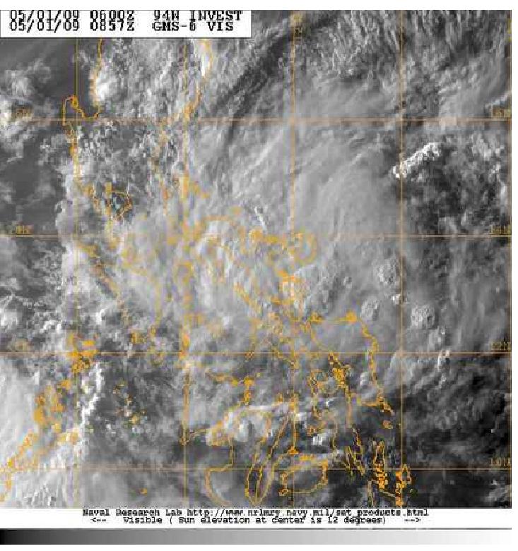
English: Early of April 27, a strong area of low pressure formed near Baler,Aurora.It is formerly a tail end of cold front that passing by in Northern Luzon. JTWC assesed that the area of a disturbed weather potential of becoming developing into a significant Tropical Cyclone within 24 hours upgraded to "fair".However, on April 28, JTWC downgraded 94W.Invest in to a dissapating stage because of interaction with Tropical Depression Crising.After a few days later,the disturbance moved south-westward.Later of April 30,the disturbance made landfall at Albay.and in May 1, JTWC upgraded again 94W.Invest into a significant Tropical Cyclone within 24 hours upgraded to "fair".And later of the day,PAGASA classified 94W.Invest into a tropical depression and named it "Dante" and issued a public storm warning signal number one in the provinces of Camarines Norte ,Camarines Sur ,Albay, Sorsogon ,Catanduanes , Masbate ,Burias Island ,Southern Quezon. |
| Date | |
| Source | Navy/NRL Tropical Cyclone Page |
| Author | Navy/NRL |
Licensing edit
This file is a work of a sailor or employee of the U.S. Navy, taken or made as part of that person's official duties. As a work of the U.S. federal government, it is in the public domain in the United States.
|
 | |
| This file has been identified as being free of known restrictions under copyright law, including all related and neighboring rights. | ||
File history
Click on a date/time to view the file as it appeared at that time.
| Date/Time | Thumbnail | Dimensions | User | Comment | |
|---|---|---|---|---|---|
| current | 12:52, 1 May 2009 | | 733 × 781 (103 KB) | Jpuligan 12 (talk | contribs) | {{Information |Description={{en|1=Early of April 27, a strong area of low pressure formed near Baler,Aurora.It is formerly a tail end of cold front that passing by in Northern Luzon. JTWC assesed that the area of a disturbed weather potential of becoming |
You cannot overwrite this file.
File usage on Commons
There are no pages that use this file.