File:PIA12328 - Crater with Exposed Layers.jpg

Original file (4,500 × 3,000 pixels, file size: 2.19 MB, MIME type: image/jpeg)
Captions
Captions
Summary
edit
| Description |
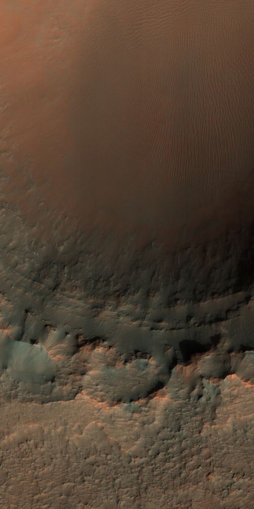
English: On Earth, geologists can dig holes and pull up core samples to find out what lies beneath the surface. On Mars, geologists cannot dig holes very easily themselves, but a process has been occurring for billions of years that has been digging holes for them: impact cratering.
Impact craters form when an asteroid, meteoroid, or comet crashes into a planet's surface, causing an explosion. The energy of the explosion, and the resulting size of the impact crater, depends on the size and density of the impactor, as well as the properties of the surface it hits. In general, the larger and denser the impactor, the larger the crater it will form. The impact crater in this image is a little less than 3 kilometers in diameter. The impact revealed layers when it excavated the Martian surface. Layers can form in a variety of different ways. Multiple lava flows in one area can form stacked sequences, as can deposits from rivers or lakes. Understanding the geology around impact craters and searching for mineralogical data within their layers can help scientists on Earth better understand what the walls of impact craters on Mars expose. The University of Arizona, Tucson, operates HiRISE, which was built by Ball Aerospace & Technologies Corp., Boulder, Colo. NASA's Jet Propulsion Laboratory, a division of Caltech in Pasadena, California, manages the Mars Reconnaissance Orbiter Project for NASA's Science Mission Directorate, Washington. |
| Date | 26 April 2008 (published 17 January 2017) |
| Source | Catalog page · Full-res (JPEG · TIFF) |
| Author | NASA/JPL-Caltech/Univ. of Arizona |
| Location on Mars | View this and other nearby images on: Google Maps |
|---|
This image or video was catalogued by Jet Propulsion Laboratory of the United States National Aeronautics and Space Administration (NASA) under Photo ID: PIA12328. This tag does not indicate the copyright status of the attached work. A normal copyright tag is still required. See Commons:Licensing. Other languages:
|
 |
This media is a product of the Mars Reconnaissance Orbiter mission Credit and attribution belongs to the High Resolution Imaging Science Experiment (HiRISE) team, NASA/JPL-Caltech/Univ. of Arizona |
Licensing
edit
| This file is in the public domain in the United States because it was solely created by NASA. NASA copyright policy states that "NASA material is not protected by copyright unless noted". (See Template:PD-USGov, NASA copyright policy page or JPL Image Use Policy.) | ||
 |
Warnings:
|
File history
Click on a date/time to view the file as it appeared at that time.
| Date/Time | Thumbnail | Dimensions | User | Comment | |
|---|---|---|---|---|---|
| current | 23:30, 17 January 2017 | | 4,500 × 3,000 (2.19 MB) | PhilipTerryGraham (talk | contribs) | User created page with UploadWizard |
You cannot overwrite this file.
File usage on Commons
The following page uses this file: