File:PIA22146 - Rabe Crater - false color.tif

Original file (680 × 1,549 pixels, file size: 2.05 MB, MIME type: image/tiff)
Captions
Captions
Summary
edit| Description |
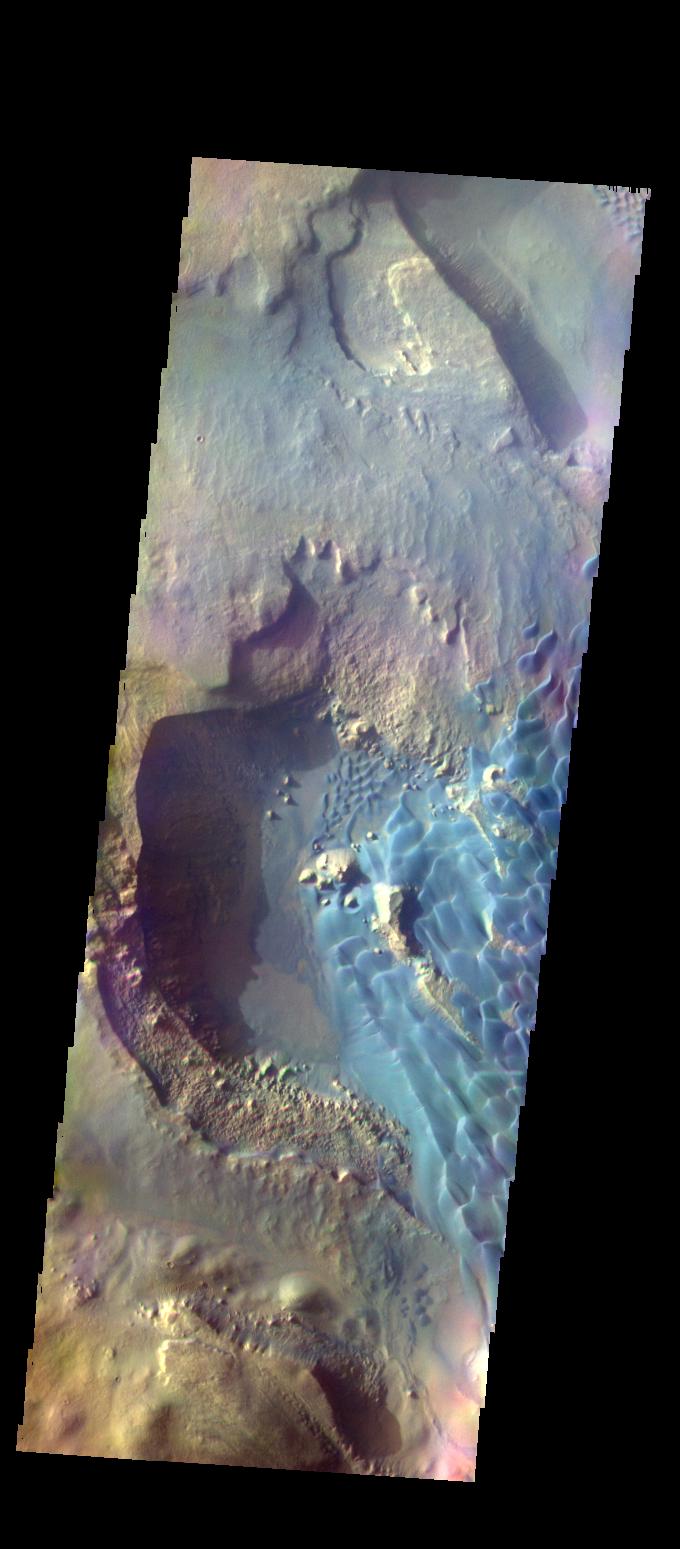
English: This is a false color image of Rabe Crater. In this combination of filters "blue" typically means basaltic sand.
Rabe Crater is 108 km (67 miles) across. Craters of similar size often have flat floors. Rabe Crater has some areas of flat floor, but also has a large complex pit occupying a substantial part of the floor. The interior fill of the crater is thought to be layered sediments created by wind and or water action. The pit is eroded into this material. The eroded materials appear to have stayed within the crater forming a large sand sheet with surface dune forms as well as individual dunes where the crater floor is visible. The dunes also appear to be moving from the upper floor level into the pit. The THEMIS VIS camera contains 5 filters. The data from different filters can be combined in multiple ways to create a false color image. These false color images may reveal subtle variations of the surface not easily identified in a single band image. The Odyssey spacecraft has spent over 15 years in orbit around Mars, circling the planet more than 69000 times. It holds the record for longest working spacecraft at Mars. THEMIS, the IR/VIS camera system, has collected data for the entire mission and provides images covering all seasons and lighting conditions. Over the years many features of interest have received repeated imaging, building up a suite of images covering the entire feature. From the deepest chasma to the tallest volcano, individual dunes inside craters and dune fields that encircle the north pole, channels carved by water and lava, and a variety of other feature, THEMIS has imaged them all. For the next several months the image of the day will focus on the Tharsis volcanoes, the various chasmata of Valles Marineris, and the major dunes fields. We hope you enjoy these images! Orbit Number: 52231 Latitude: -43.6665 Longitude: 34.2627 Instrument: VIS Captured: 2013-09-22 14:29 Please see the THEMIS Data Citation Note for details on crediting THEMIS images. NASA's Jet Propulsion Laboratory manages the 2001 Mars Odyssey mission for NASA's Science Mission Directorate, Washington, D.C. The Thermal Emission Imaging System (THEMIS) was developed by Arizona State University, Tempe, in collaboration with Raytheon Santa Barbara Remote Sensing. The THEMIS investigation is led by Dr. Philip Christensen at Arizona State University. Lockheed Martin Astronautics, Denver, is the prime contractor for the Odyssey project, and developed and built the orbiter. Mission operations are conducted jointly from Lockheed Martin and from JPL, a division of the California Institute of Technology in Pasadena. |
| Date | (published 2017-12-20) |
| Source | Catalog page · Full-res (JPEG · TIFF) |
| Author | NASA/JPL-Caltech/ASU |
| Location on Mars | View this and other nearby images on: Google Maps |
|---|
This image or video was catalogued by Jet Propulsion Laboratory of the United States National Aeronautics and Space Administration (NASA) under Photo ID: PIA22146. This tag does not indicate the copyright status of the attached work. A normal copyright tag is still required. See Commons:Licensing. Other languages:
|
| This media is a product of the 2001 Mars Odyssey mission Credit and attribution belongs to the Thermal Emission Imaging System (THEMIS) team, NASA/JPL-Caltech/ASU |
Licensing
edit| This file is in the public domain in the United States because it was solely created by NASA. NASA copyright policy states that "NASA material is not protected by copyright unless noted". (See Template:PD-USGov, NASA copyright policy page or JPL Image Use Policy.) | ||
 |
Warnings:
|
File history
Click on a date/time to view the file as it appeared at that time.
| Date/Time | Thumbnail | Dimensions | User | Comment | |
|---|---|---|---|---|---|
| current | 02:40, 22 January 2018 |  | 680 × 1,549 (2.05 MB) | Jarnsax (talk | contribs) | =={{int:filedesc}}== {{NASA Photojournal | catalog = PIA22146 | image = yes | mission = 2001 Mars Odyssey | instrument = Thermal Emission Imaging System | caption = {{en|This is a false color image of {{w|Rabe Crater}}. In... |
You cannot overwrite this file.
File usage on Commons
The following page uses this file: