File:PIA22158 - Arsia Mons.tif

Original file (1,142 × 2,772 pixels, file size: 2.05 MB, MIME type: image/tiff)
Captions
Captions
Summary edit
| Description |
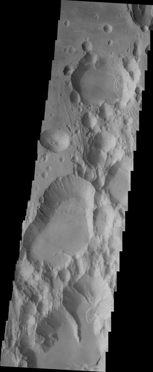
English: The three large aligned Tharsis volcanoes are Arsia Mons, Pavonis Mons and Ascreaus Mons (from south to north). There are collapse features on all three volcanoes, on the southwestern and northeastern flanks. This alignment may indicate a large fracture/vent system was responsible for the eruptions that formed all three volcanoes. This VIS image shows part of the southern flank of Arsia Mons, along the center of the aligned fracture system. The scalloped depressions are most likely created by collapse of the roof of lava tubes. Lava tubes originate during eruption event, when the margins of a flow harden around a still flowing lava stream. When an eruption ends these can become hollow tubes within the flow. With time, the roof of the tube may collapse into the empty space below. The tubes are linear, so the collapse of the roof creates a linear depression. In this region, the complexity of the collapse and faulting has created a unique surface. This region has collapse depressions with floors at a variety of elevations, landslide deposits where material has continued to fall into the depression and depression sizes from small to large.
Arsia Mons is the southernmost of the Tharsis volcanoes. It is 270 miles (450km) in diameter, almost 12 miles (20km) high, and the summit caldera is 72 miles (120km) wide. For comparison, the largest volcano on Earth is Mauna Loa. From its base on the sea floor, Mauna Loa measures only 6.3 miles high and 75 miles in diameter. A large volcanic crater known as a caldera is located at the summit of all of the Tharsis volcanoes. These calderas are produced by massive volcanic explosions and collapse. The Arsia Mons summit caldera is larger than many volcanoes on Earth. The Odyssey spacecraft has spent over 15 years in orbit around Mars, circling the planet more than 69000 times. It holds the record for longest working spacecraft at Mars. THEMIS, the IR/VIS camera system, has collected data for the entire mission and provides images covering all seasons and lighting conditions. Over the years many features of interest have received repeated imaging, building up a suite of images covering the entire feature. From the deepest chasma to the tallest volcano, individual dunes inside craters and dune fields that encircle the north pole, channels carved by water and lava, and a variety of other feature, THEMIS has imaged them all. For the next several months the image of the day will focus on the Tharsis volcanoes, the various chasmata of Valles Marineris, and the major dunes fields. We hope you enjoy these images! Orbit Number: 33925 Latitude: -10.6619 Longitude: 239.412 Instrument: VIS Captured: 2009-08-07 16:10 Please see the THEMIS Data Citation Note for details on crediting THEMIS images. NASA's Jet Propulsion Laboratory manages the 2001 Mars Odyssey mission for NASA's Science Mission Directorate, Washington, D.C. The Thermal Emission Imaging System (THEMIS) was developed by Arizona State University, Tempe, in collaboration with Raytheon Santa Barbara Remote Sensing. The THEMIS investigation is led by Dr. Philip Christensen at Arizona State University. Lockheed Martin Astronautics, Denver, is the prime contractor for the Odyssey project, and developed and built the orbiter. Mission operations are conducted jointly from Lockheed Martin and from JPL, a division of the California Institute of Technology in Pasadena. |
| Date | (published 2018-01-04) |
| Source | Catalog page · Full-res (JPEG · TIFF) |
| Author | NASA/JPL-Caltech/ASU |
| Location on Mars | View this and other nearby images on: Google Maps |
|---|
This image or video was catalogued by Jet Propulsion Laboratory of the United States National Aeronautics and Space Administration (NASA) under Photo ID: PIA22158. This tag does not indicate the copyright status of the attached work. A normal copyright tag is still required. See Commons:Licensing. Other languages:
|
| This media is a product of the 2001 Mars Odyssey mission Credit and attribution belongs to the Thermal Emission Imaging System (THEMIS) team, NASA/JPL-Caltech/ASU |
Licensing edit
| This file is in the public domain in the United States because it was solely created by NASA. NASA copyright policy states that "NASA material is not protected by copyright unless noted". (See Template:PD-USGov, NASA copyright policy page or JPL Image Use Policy.) | ||
 |
Warnings:
|
File history
Click on a date/time to view the file as it appeared at that time.
| Date/Time | Thumbnail | Dimensions | User | Comment | |
|---|---|---|---|---|---|
| current | 20:36, 20 January 2018 | 1,142 × 2,772 (2.05 MB) | Jarnsax (talk | contribs) | =={{int:filedesc}}== {{NASA Photojournal | catalog = PIA22158 | image = yes | mission = 2001 Mars Odyssey | instrument = Thermal Emission Imaging System | caption = {{en|The three large aligned {{w|Tharsis}} volcanoes are {... |
You cannot overwrite this file.
File usage on Commons
The following page uses this file: