File:PIA22162 - Candor Chasma.tif

Original file (1,357 × 3,059 pixels, file size: 2.65 MB, MIME type: image/tiff)
Captions
Captions
Summary edit
| Description |
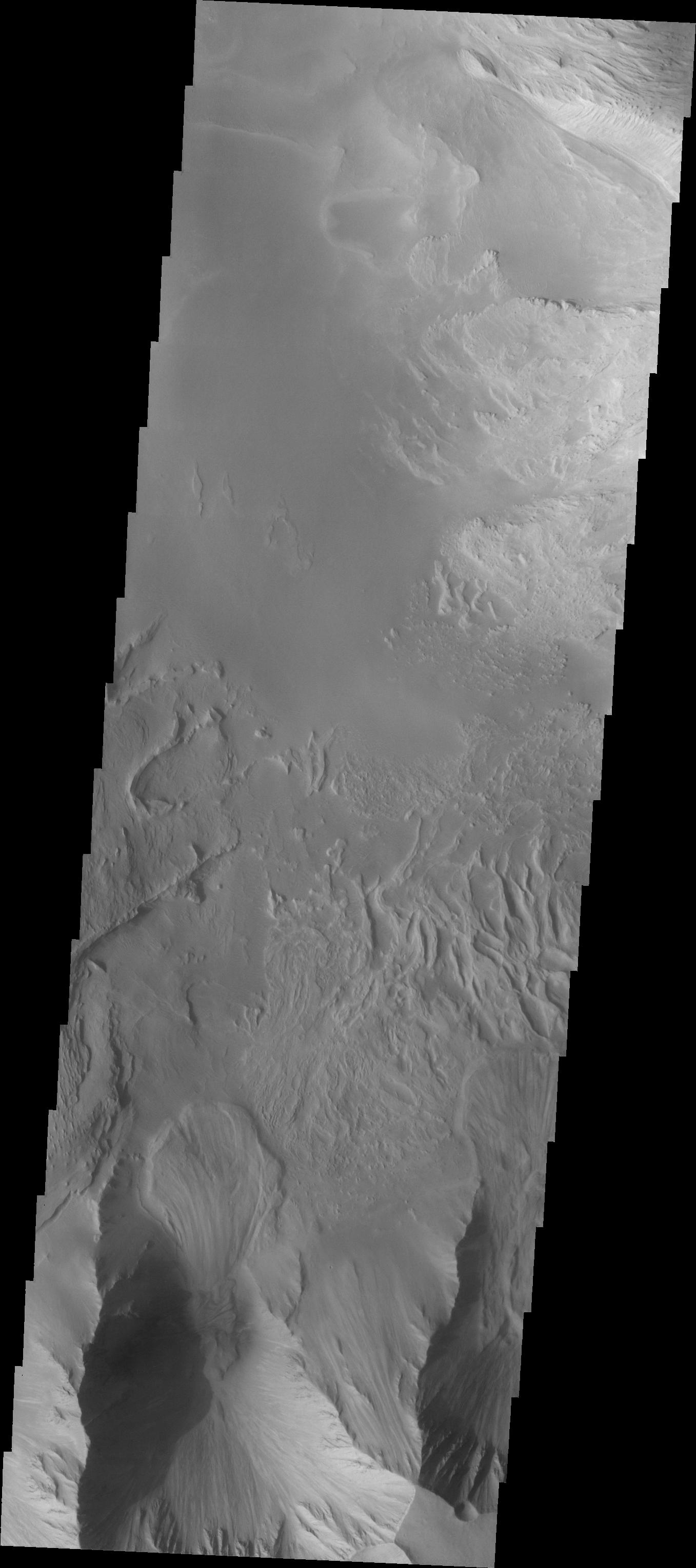
English: This image shows part of eastern Candor Chasma. At the bottom of the image is the steep cliff between the upper surface elevation and the depths of Candor Chasma. The small lobate feature at the base of the cliff in the bottom of the image is a landslide deposit formed by failure of the cliff face and gravitational downslope movement of the material.
Candor Chasma is one of the largest canyons that make up Valles Marineris. It is approximately 810 km long (503 miles) and has is divided into two regions - eastern and western Candor. Candor is located south of Ophir Chasma and north of Melas Chasma. The border with Melas Chasma contains many large landslide deposits. The floor of Candor Chasma includes a variety of landforms, including layered deposits, dunes, landslide deposits and steep sided cliffs and mesas. Many forms of erosion have shaped Chandor Chasma. There is evidence of wind and water erosion, as well as significant gravity driven mass wasting (landslides). The Odyssey spacecraft has spent over 15 years in orbit around Mars, circling the planet more than 69000 times. It holds the record for longest working spacecraft at Mars. THEMIS, the IR/VIS camera system, has collected data for the entire mission and provides images covering all seasons and lighting conditions. Over the years many features of interest have received repeated imaging, building up a suite of images covering the entire feature. From the deepest chasma to the tallest volcano, individual dunes inside craters and dune fields that encircle the north pole, channels carved by water and lava, and a variety of other feature, THEMIS has imaged them all. For the next several months the image of the day will focus on the Tharsis volcanoes, the various chasmata of Valles Marineris, and the major dunes fields. We hope you enjoy these images! Orbit Number: 8916 Latitude: -7.95016 Longitude: 293.509 Instrument: VIS Captured: 2003-12-18 11:38 Please see the THEMIS Data Citation Note for details on crediting THEMIS images. NASA's Jet Propulsion Laboratory manages the 2001 Mars Odyssey mission for NASA's Science Mission Directorate, Washington, D.C. The Thermal Emission Imaging System (THEMIS) was developed by Arizona State University, Tempe, in collaboration with Raytheon Santa Barbara Remote Sensing. The THEMIS investigation is led by Dr. Philip Christensen at Arizona State University. Lockheed Martin Astronautics, Denver, is the prime contractor for the Odyssey project, and developed and built the orbiter. Mission operations are conducted jointly from Lockheed Martin and from JPL, a division of the California Institute of Technology in Pasadena. |
| Date | (published 2018-01-10) |
| Source | Catalog page · Full-res (JPEG · TIFF) |
| Author | NASA/JPL-Caltech/ASU |
| Location on Mars | View this and other nearby images on: Google Maps |
|---|
This image or video was catalogued by Jet Propulsion Laboratory of the United States National Aeronautics and Space Administration (NASA) under Photo ID: PIA22162. This tag does not indicate the copyright status of the attached work. A normal copyright tag is still required. See Commons:Licensing. Other languages:
|
| This media is a product of the 2001 Mars Odyssey mission Credit and attribution belongs to the Thermal Emission Imaging System (THEMIS) team, NASA/JPL-Caltech/ASU |
Licensing edit
| This file is in the public domain in the United States because it was solely created by NASA. NASA copyright policy states that "NASA material is not protected by copyright unless noted". (See Template:PD-USGov, NASA copyright policy page or JPL Image Use Policy.) | ||
 |
Warnings:
|
File history
Click on a date/time to view the file as it appeared at that time.
| Date/Time | Thumbnail | Dimensions | User | Comment | |
|---|---|---|---|---|---|
| current | 19:49, 20 January 2018 |  | 1,357 × 3,059 (2.65 MB) | Jarnsax (talk | contribs) | =={{int:filedesc}}== {{NASA Photojournal | catalog = PIA22162 | image = yes | mission = 2001 Mars Odyssey | instrument = Thermal Emission Imaging System | caption = {{en|This image shows part of eastern {{w|Candor Chasma}}.... |
You cannot overwrite this file.
File usage on Commons
The following page uses this file: