File:PL droga ekspresowa S79.svg

Size of this PNG preview of this SVG file: 743 × 599 pixels. Other resolutions: 298 × 240 pixels | 595 × 480 pixels | 952 × 768 pixels | 1,270 × 1,024 pixels | 2,539 × 2,048 pixels | 1,199 × 967 pixels.
Original file (SVG file, nominally 1,199 × 967 pixels, file size: 72 KB)
Captions
Captions
Add a one-line explanation of what this file represents
| Description |
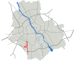
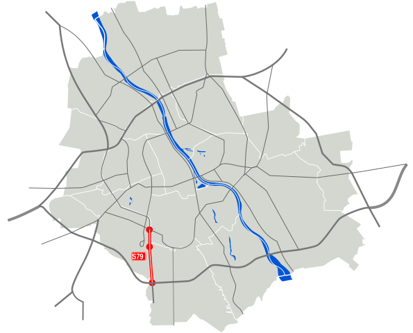
Polski: Droga ekspresowa S79
English: S79 expressway
Deutsch: Schnellstraße S79 in Warschau |
| Date | |
| Source | |
| Author |
|
| This is a retouched picture, which means that it has been digitally altered from its original version. Modifications: S79 Expressway. The original can be viewed here: WarszawaDocelowyUkladDrog.svg:
|
I, the copyright holder of this work, hereby publish it under the following licenses:
This file is licensed under the Creative Commons Attribution 3.0 Unported license.
- You are free:
- to share – to copy, distribute and transmit the work
- to remix – to adapt the work
- Under the following conditions:
- attribution – You must give appropriate credit, provide a link to the license, and indicate if changes were made. You may do so in any reasonable manner, but not in any way that suggests the licensor endorses you or your use.
You may select the license of your choice.
Original upload log
editThis image is a derivative work of the following images:
- File:WarszawaDocelowyUkladDrog.svg licensed with Cc-by-3.0, Cc-by-3.0
- 2009-09-02T18:47:12Z Sliwers 1199x967 (87777 Bytes) {{Information |Description={{pl|Docelowy układ dróg klasy A, S i GP w Warszawie.}} {{en|Map of the planned motorways in Warsaw.}} |Source=*[[:File:Warszawa_outline_with_districts_v2.svg|]] |Date=2009-09-02 18:46 (UTC) |Auth
| Annotations | This image is annotated: View the annotations at Commons |


File history
Click on a date/time to view the file as it appeared at that time.
| Date/Time | Thumbnail | Dimensions | User | Comment | |
|---|---|---|---|---|---|
| current | 15:20, 22 November 2009 | | 1,199 × 967 (72 KB) | Sliwers (talk | contribs) | Exits via notes |
| 12:07, 22 November 2009 |  | 1,199 × 967 (101 KB) | Sliwers (talk | contribs) | Exits | |
| 20:30, 2 September 2009 |  | 1,199 × 967 (69 KB) | Sliwers (talk | contribs) | Thicker line | |
| 20:05, 2 September 2009 |  | 1,199 × 967 (69 KB) | Sliwers (talk | contribs) | Use map of Warsaw instead of Poland as background | |
| 19:07, 4 May 2006 |  | 610 × 572 (76 KB) | Malarz pl (talk | contribs) | '''(en)''' Polish expressway S79 marked on map of polish planned free- and expressway network '''(pl)''' Polska droga ekspresowa S79 zaznaczona na mapie planowanej sieci autostrad i dróg ekspresowych w Polsce {{cc-by-2.5}} Map drawed by [[:pl:user:ma |
You cannot overwrite this file.
File usage on Commons
The following page uses this file:
File usage on other wikis
The following other wikis use this file:
- Usage on cs.wikipedia.org
- Usage on de.wikipedia.org
- Usage on en.wikipedia.org
- Usage on ja.wikipedia.org
- Usage on pl.wikipedia.org
- Usage on www.wikidata.org