File:PL free- and expressways network.svg

Size of this PNG preview of this SVG file: 610 × 572 pixels. Other resolutions: 256 × 240 pixels | 512 × 480 pixels | 819 × 768 pixels | 1,092 × 1,024 pixels | 2,184 × 2,048 pixels.
Original file (SVG file, nominally 610 × 572 pixels, file size: 74 KB)
Captions
Captions
Add a one-line explanation of what this file represents
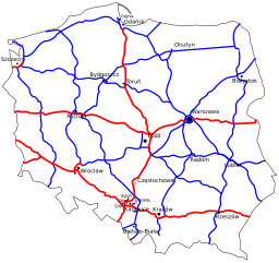
(en) map of polish planned free- and expressway network
- highway
- expressway
(pl) mapa planowanej sieci autostrad i dróg ekspresowych w Polsce
- autostrady
- drogi ekspresowe
(de) Das Autobahn- und Schnellstraßennetz Polens, geplanter Endzustand
- Autobahnen
- Schnellstraßen
This file is licensed under the Creative Commons Attribution-Share Alike 2.5 Generic license.
- You are free:
- to share – to copy, distribute and transmit the work
- to remix – to adapt the work
- Under the following conditions:
- attribution – You must give appropriate credit, provide a link to the license, and indicate if changes were made. You may do so in any reasonable manner, but not in any way that suggests the licensor endorses you or your use.
- share alike – If you remix, transform, or build upon the material, you must distribute your contributions under the same or compatible license as the original.
Map drawn by malarz pl based upon information from pl:GDDKiA page.
File history
Click on a date/time to view the file as it appeared at that time.
| Date/Time | Thumbnail | Dimensions | User | Comment | |
|---|---|---|---|---|---|
| current | 04:55, 19 October 2009 | | 610 × 572 (74 KB) | Siwulek (talk | contribs) | technical corrections Drobne poprawki techniczne. |
| 20:21, 4 May 2006 |  | 610 × 572 (73 KB) | Malarz pl (talk | contribs) | '''(en)''' map of polish planned free- and expressway network * <span style="color: red;">freeway</span> * <span style="color: blue;">expressway</span> '''(pl)''' mapa planowanej sieci autostrad i dróg ekspresowych w Polsce * <span style="color: red;">a |
You cannot overwrite this file.
File usage on Commons
There are no pages that use this file.
File usage on other wikis
The following other wikis use this file:
- Usage on eo.wikipedia.org
- Usage on hu.wikipedia.org
- Usage on ja.wikipedia.org
- Usage on pl.wikipedia.org