File:POL Tatry.png

Size of this preview: 800 × 396 pixels. Other resolutions: 320 × 158 pixels | 812 × 402 pixels.
Original file (812 × 402 pixels, file size: 300 KB, MIME type: image/png)
Captions
Captions
Add a one-line explanation of what this file represents
| Description |
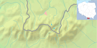
English: Map of the Tatra Mountains Polski: Mapa Tatr |
| Date | |
| Source | |
| Author | |
| Other versions |
File:POL Tatry.svg:  |


| This is a retouched picture, which means that it has been digitally altered from its original version. Modifications: combined the maps, via autotrace first in INkscape, drawing a proportional rectangle on inset the country map to aid localizing.. The original can be viewed here: Poland location map white.svg:
|
This file is licensed under the Creative Commons Attribution-Share Alike 3.0 Unported license.
- You are free:
- to share – to copy, distribute and transmit the work
- to remix – to adapt the work
- Under the following conditions:
- attribution – You must give appropriate credit, provide a link to the license, and indicate if changes were made. You may do so in any reasonable manner, but not in any way that suggests the licensor endorses you or your use.
- share alike – If you remix, transform, or build upon the material, you must distribute your contributions under the same or compatible license as the original.
Original upload log edit
This image is a derivative work of the following images:
- File:Tatry_mapa_2.png licensed with PD-Demis
- 2008-09-02T21:41:25Z ToSter 811x401 (305387 Bytes) {{Information |Description={{en|1=Map of the Tatra Mountains}} {{pl|1=Mapa Tatr}} |Source=PD map from Demis - modified version of [[:Image:Tatry mapa.png]] by [[User:Botev]] |Author=[[User:ToSter|ToSter]] |Date=Sep 2nd, 2008
- File:Poland_location_map_white.svg licensed with Cc-by-sa-3.0, Cc-by-sa-3.0/en
- 2009-01-29T00:51:50Z Mareklug 862x838 (358904 Bytes) {{Information |Description={{de| Positionskarte von Polen auf weissem Hintergrund. Quadratische Plattkarte, N-S-Streckung 160 %. Geographische Begrenzung der Karte: * N: 55.2° N * S: 48.7° N * W: 13.8° O * O: 24.5° O {{en
File history
Click on a date/time to view the file as it appeared at that time.
| Date/Time | Thumbnail | Dimensions | User | Comment | |
|---|---|---|---|---|---|
| current | 13:38, 10 February 2009 | | 812 × 402 (300 KB) | Mareklug (talk | contribs) | {{Information |Description={{en|1=Map of Tatra mountains}} {{pl|1=Mapa Tatr}} |Source=own work, derived work |Author=Mareklug |Date=2009-02-11 |Permission= |other_versions=File:POL_Tatry.svg }} <!--{{ImageUpload|full}}--> |
You cannot overwrite this file.
File usage on Commons
The following 3 pages use this file:
File usage on other wikis
The following other wikis use this file:
- Usage on pl.wikipedia.org