File:PP Ratajské rybníky, CZ160317 - mokřady u Dolního ratajského rybníku.JPG
Original file (2,523 × 1,884 pixels, file size: 2.73 MB, MIME type: image/jpeg)
Captions
Captions
Summary
editDescriptionPP Ratajské rybníky, CZ160317 - mokřady u Dolního ratajského rybníku.JPG |
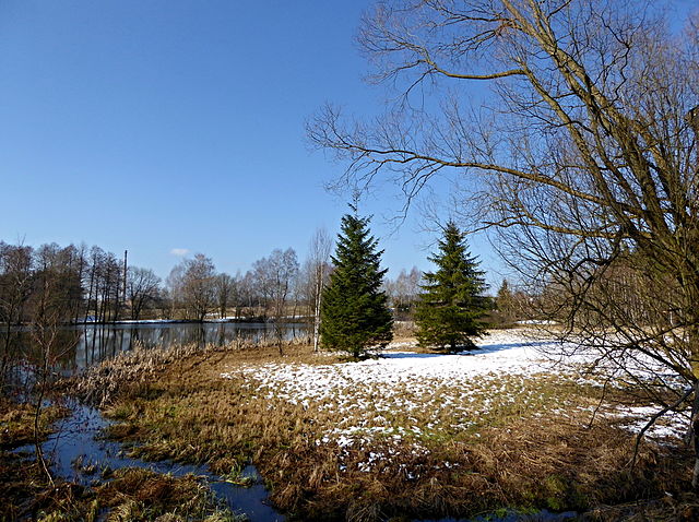
English: Natural Monument "Ratajské" ponds and locality of European importance in the Czech Republic. Snow on the banks of ponds - early spring of "Kameničské" Highlands. Photo location: Czechia, Pardubice Region, Hlinsko town.
Čeština: Přírodní památka Ratajské rybníky a evropsky významná lokalita v České republice. Sníh na březích rybníků - časné jaro Kameničské vrchoviny. Foto lokace: Česko, Pardubický kraj, město Hlinsko. |
Date | |
Source | Own work |
Author | Josef Kreuz (PEPan) |
Camera location | 49° 46′ 09.65″ N, 15° 56′ 05.76″ E ![]() | View this and other nearby images on: OpenStreetMap | ![]() |
---|
Faktografie
editMokřady a břehové porosty se solitérními smrky na úzkém pásu mezi rybníky s pomístními jmény Dolní Rataják a Prostřední Rataják (zeměpisným názvem Dolní ratajský rybník a blíže nepojmenovaným (prostředním) rybníkem z rybniční soustavy tří vodních nádrží. Území je přírodní památkou Ratajské rybníky, kterou překrývá rozsáhlejší stejnojmenné území evropsky významné lokality v projektu NATURA 2000, který je společným pro všechny státy Evropské unie. Poznámka: Mezi stromy za hrází rybníku je patrný komín teplárny v městě Hlinsko. Dokumentární fotografie.
Externí odkazy
editRatajské rybníky a okolí - turistická mapa
Licensing
edit![w:en:Creative Commons](https://upload.wikimedia.org/wikipedia/commons/thumb/7/79/CC_some_rights_reserved.svg/90px-CC_some_rights_reserved.svg.png)
![attribution](https://upload.wikimedia.org/wikipedia/commons/thumb/1/11/Cc-by_new_white.svg/24px-Cc-by_new_white.svg.png)
![share alike](https://upload.wikimedia.org/wikipedia/commons/thumb/d/df/Cc-sa_white.svg/24px-Cc-sa_white.svg.png)
- You are free:
- to share – to copy, distribute and transmit the work
- to remix – to adapt the work
- Under the following conditions:
- attribution – You must give appropriate credit, provide a link to the license, and indicate if changes were made. You may do so in any reasonable manner, but not in any way that suggests the licensor endorses you or your use.
- share alike – If you remix, transform, or build upon the material, you must distribute your contributions under the same or compatible license as the original.
File history
Click on a date/time to view the file as it appeared at that time.
Date/Time | Thumbnail | Dimensions | User | Comment | |
---|---|---|---|---|---|
current | 14:32, 30 March 2016 | 2,523 × 1,884 (2.73 MB) | PEPan (talk | contribs) | User created page with UploadWizard |
You cannot overwrite this file.
File usage on Commons
There are no pages that use this file.
File usage on other wikis
The following other wikis use this file:
- Usage on cs.wikipedia.org
Metadata
This file contains additional information such as Exif metadata which may have been added by the digital camera, scanner, or software program used to create or digitize it. If the file has been modified from its original state, some details such as the timestamp may not fully reflect those of the original file. The timestamp is only as accurate as the clock in the camera, and it may be completely wrong.
Camera manufacturer | Panasonic |
---|---|
Camera model | DMC-TZ60 |
Author | Josef Kreuz |
Exposure time | 1/1,000 sec (0.001) |
F-number | f/3.3 |
ISO speed rating | 100 |
Date and time of data generation | 10:21, 17 March 2016 |
Lens focal length | 4.3 mm |
User comments | Přírodní památka Ratajské rybníky, CZ160317 © Josef Kreuz PS : Mokřady a břehové porosty se solitérními smrky u Dolního ratajského rybníku pod hrází bezejmenného (prostředního) rybníku na území Přírodní památky Ratajské rybníky, kterou tzv. překrývá rozsáhlejší území Evropsky významné lokality. |
Latitude | 49° 46′ 9.65″ N |
Longitude | 15° 56′ 5.75″ E |
Label | Red |
Short title |
|
Image title |
|
Compression scheme | Uncompressed |
Pixel composition | RGB |
Orientation | Normal |
Horizontal resolution | 180 dpi |
Vertical resolution | 180 dpi |
Data arrangement | chunky format |
Software used | Ver.1.0 |
File change date and time | 15:18, 30 March 2016 |
Y and C positioning | Centered |
Exposure Program | Normal program |
Exif version | 2.3 |
Date and time of digitizing | 10:21, 17 March 2016 |
Meaning of each component |
|
Image compression mode | 4 |
APEX exposure bias | 0 |
Maximum land aperture | 3.4453125 APEX (f/3.3) |
Metering mode | Pattern |
Light source | Unknown |
Flash | Flash did not fire, compulsory flash suppression |
Supported Flashpix version | 1 |
Color space | sRGB |
Sensing method | One-chip color area sensor |
File source | Digital still camera |
Scene type | A directly photographed image |
Custom image processing | Normal process |
Exposure mode | Auto exposure |
White balance | Auto white balance |
Digital zoom ratio | 0 |
Focal length in 35 mm film | 25 mm |
Scene capture type | Standard |
Scene control | None |
Contrast | Normal |
Saturation | Normal |
Sharpness | Normal |
Unique image ID | b2fc824aaa98646c6708ef4058b8c282 |
GPS tag version | 0.0.2.2 |