File:Paddentrek bord.jpg

Size of this preview: 398 × 599 pixels. Other resolutions: 159 × 240 pixels | 319 × 480 pixels | 510 × 768 pixels | 681 × 1,024 pixels | 2,000 × 3,008 pixels.
Original file (2,000 × 3,008 pixels, file size: 1.57 MB, MIME type: image/jpeg)
Captions
Captions
Add a one-line explanation of what this file represents
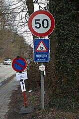
| Description | Verkeersborden en paddentrekwaarschuwing. | ||
| Date | |||
| Source | Own work | ||
| Author | Wouter Hagens | ||
| Permission (Reusing this file) |
|
| Camera location | | View this and other nearby images on: OpenStreetMap |
|---|
File history
Click on a date/time to view the file as it appeared at that time.
| Date/Time | Thumbnail | Dimensions | User | Comment | |
|---|---|---|---|---|---|
| current | 13:40, 7 March 2007 | | 2,000 × 3,008 (1.57 MB) | Wouterhagens (talk | contribs) | {{Information |Description=Verkeersborden en paddentrekwaarschuwing. Coördinaten {{coor dms|50|49|22.28|N|4|39|29.27|E|scale:4000}}. |Source=own work |Date=2007-03-04|Author=Wouter Hagens |Permission={{PD-self}} }} [[Category:Signs |
You cannot overwrite this file.
File usage on Commons
There are no pages that use this file.