File:PaganiaZahumljeTravuniaDuklja.svg

Size of this PNG preview of this SVG file: 800 × 586 pixels. Other resolutions: 320 × 235 pixels | 640 × 469 pixels | 1,024 × 751 pixels | 1,280 × 938 pixels | 2,560 × 1,876 pixels | 805 × 590 pixels.
Original file (SVG file, nominally 805 × 590 pixels, file size: 1.08 MB)
Captions
Captions
Add a one-line explanation of what this file represents
Summary
edit
| Description |
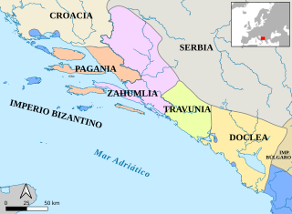
English: Historic map of medieval Dalmatian principalities (Pagania, Zachlumia, Travunia and Doclea) in the 9th century . Srpski (latinica): Istorijska karta srednjovekovnih dalmatinskih kneževina (Paganije, Zahumlja, Travunije i Duklje) u 9. veku Español: Los principados dálamatas (Pagania, Zahumlia, Travunia y Doclea) en el siglo IX. |
| Date | |
| Source | |
| Author |
|
Licensing
edit
I, the copyright holder of this work, hereby publish it under the following license:
This file is licensed under the Creative Commons Attribution-Share Alike 3.0 Unported license.
- You are free:
- to share – to copy, distribute and transmit the work
- to remix – to adapt the work
- Under the following conditions:
- attribution – You must give appropriate credit, provide a link to the license, and indicate if changes were made. You may do so in any reasonable manner, but not in any way that suggests the licensor endorses you or your use.
- share alike – If you remix, transform, or build upon the material, you must distribute your contributions under the same or compatible license as the original.
File history
Click on a date/time to view the file as it appeared at that time.
| Date/Time | Thumbnail | Dimensions | User | Comment | |
|---|---|---|---|---|---|
| current | 11:42, 25 October 2021 | | 805 × 590 (1.08 MB) | Rowanwindwhistler (talk | contribs) | New version, using projection EPSG3857, rivers (ECRIN). Lakes, coasts from GSHHG |
| 05:38, 6 October 2016 |  | 698 × 486 (110 KB) | Rowanwindwhistler (talk | contribs) | Fake text added, real text hidden | |
| 08:47, 24 August 2016 |  | 698 × 486 (57 KB) | Rowanwindwhistler (talk | contribs) | https://en.wikipedia.org/wiki/Wikipedia:WikiProject_Maps/Conventions | |
| 18:09, 17 March 2014 |  | 698 × 486 (46 KB) | Rowanwindwhistler (talk | contribs) | Slight changes in state borders. | |
| 18:04, 17 March 2014 |  | 698 × 486 (103 KB) | Rowanwindwhistler (talk | contribs) | User created page with UploadWizard |
You cannot overwrite this file.
File usage on Commons
The following 4 pages use this file:
File usage on other wikis
The following other wikis use this file: