File:Pajares Nord-Rampe.png

Size of this preview: 458 × 600 pixels. Other resolutions: 183 × 240 pixels | 367 × 480 pixels | 587 × 768 pixels | 782 × 1,024 pixels | 2,028 × 2,655 pixels.
Original file (2,028 × 2,655 pixels, file size: 2.21 MB, MIME type: image/png)
Captions
Captions
Add a one-line explanation of what this file represents
Summary
edit
| Description |
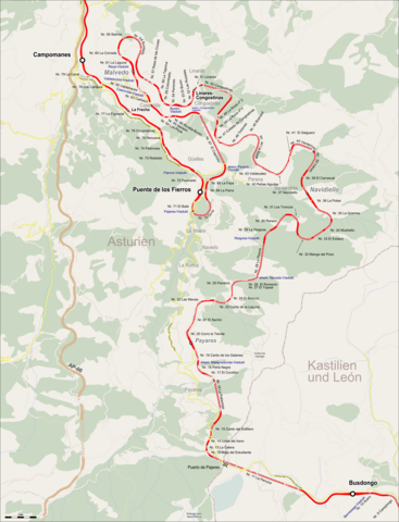
Deutsch: Karte der Streckenentwicklung an der Pajares-Nordrampe |
| Date | |
| Source |
Map was created using: |
| Creator |
|
| Permission (Reusing this file) |
|
| Georeferencing | If inappropriate please set warp_status = skip to hide. |
Licensing
edit
I, the copyright holder of this work, hereby publish it under the following license:
This file is licensed under the Creative Commons Attribution-Share Alike 3.0 Unported license.
Attribution: Peter Christener
- You are free:
- to share – to copy, distribute and transmit the work
- to remix – to adapt the work
- Under the following conditions:
- attribution – You must give appropriate credit, provide a link to the license, and indicate if changes were made. You may do so in any reasonable manner, but not in any way that suggests the licensor endorses you or your use.
- share alike – If you remix, transform, or build upon the material, you must distribute your contributions under the same or compatible license as the original.
| This work is licensed under the Open Database License (summary). |
File history
Click on a date/time to view the file as it appeared at that time.
| Date/Time | Thumbnail | Dimensions | User | Comment | |
|---|---|---|---|---|---|
| current | 17:36, 30 December 2017 | | 2,028 × 2,655 (2.21 MB) | Pechristener (talk | contribs) | kleine Korrekturen: Pfeil unter einer Strasse, Name des Tunnel 72 |
| 07:08, 29 December 2017 |  | 2,028 × 2,655 (2.21 MB) | Pechristener (talk | contribs) | Navedo-Viadukt war Raigosa-Viadukt eingetragen | |
| 02:25, 29 December 2017 |  | 2,028 × 2,655 (2.21 MB) | Pechristener (talk | contribs) | {{Map |Description={{de|Karte der Strecenentwiclung an der Pajares-Nordrampe}} |Source= Map was created using: *[http://www.openstreetmap.org/ Open Street Map] |Author= *Open Street Map Data: [http://www.openstreetmap.org OpenStreetMap] and contribut... |
You cannot overwrite this file.
File usage on Commons
The following 5 pages use this file:
File usage on other wikis
The following other wikis use this file:
- Usage on de.wikipedia.org