File:Palm Bay.jpg
No higher resolution available.
Palm_Bay.jpg (640 × 480 pixels, file size: 116 KB, MIME type: image/jpeg)
Captions
Captions
Add a one-line explanation of what this file represents
| Description |
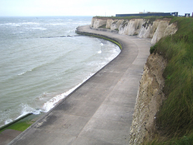
English: Palm Bay, Cliftonville, Kent, England. This is the eastern end of Palm Bay showing the cliffs and sea defences leading round to Foreness Point. The rectangular black slab on the top of the cliff is the boundary wall of Southern Water's construction site where improvements are currently being made to the Foreness Point Wastewater Treatment Works. |
| Date | |
| Source | From geograph.org.uk |
| Author | Nigel Cox |
| Permission (Reusing this file) |
Creative Commons Attribution Share-alike license 2.0 |
| Attribution (required by the license) | Nigel Cox / Cliftonville: Palm Bay / |
| Camera location | | View this and other nearby images on: OpenStreetMap |
|---|

|
This image was taken from the Geograph project collection. See this photograph's page on the Geograph website for the photographer's contact details. The copyright on this image is owned by Nigel Cox and is licensed for reuse under the Creative Commons Attribution-ShareAlike 2.0 license.
|
This file is licensed under the Creative Commons Attribution-Share Alike 2.0 Generic license.
Attribution: Nigel Cox
- You are free:
- to share – to copy, distribute and transmit the work
- to remix – to adapt the work
- Under the following conditions:
- attribution – You must give appropriate credit, provide a link to the license, and indicate if changes were made. You may do so in any reasonable manner, but not in any way that suggests the licensor endorses you or your use.
- share alike – If you remix, transform, or build upon the material, you must distribute your contributions under the same or compatible license as the original.
Original upload log edit
The original description page was here. All following user names refer to en.wikipedia.
- 2007-08-04 18:27 Epbr123 640×480× (119262 bytes) Obtained from https://www.geograph.org.uk/photo/461428 Image placed under the Creative Commons Attribution-ShareAlike License by its owner, Nigel Cox
File history
Click on a date/time to view the file as it appeared at that time.
| Date/Time | Thumbnail | Dimensions | User | Comment | |
|---|---|---|---|---|---|
| current | 14:14, 22 November 2008 | | 640 × 480 (116 KB) | Angusmclellan (talk | contribs) | {{Information |Description={{en|Palm Bay, Cliftonville, Kent, England. This is the eastern end of Palm Bay showing the cliffs and sea defences leading round to Foreness Point. The rectangular black slab on the top of the cliff is the boundary wall of Sout |
You cannot overwrite this file.
File usage on Commons
There are no pages that use this file.
File usage on other wikis
The following other wikis use this file:
- Usage on en.wikipedia.org
- Usage on www.wikidata.org