File:Panorama of Seattle, 1878 (MOHAI 9760).jpg
Panorama_of_Seattle,_1878_(MOHAI_9760).jpg (700 × 211 pixels, file size: 33 KB, MIME type: image/jpeg)
Captions
Captions
Summary edit
| English: Panorama of Seattle, 1878
( |
||||||||||||||||||||||||
|---|---|---|---|---|---|---|---|---|---|---|---|---|---|---|---|---|---|---|---|---|---|---|---|---|
| Photographer |
English: Peterson Bros. |
|||||||||||||||||||||||
| Title |
English: Panorama of Seattle, 1878 |
|||||||||||||||||||||||
| Description |
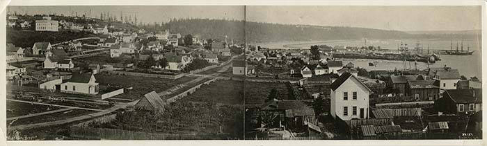
English: This image of Seattle faces southeast across Pike Street, toward Mount Rainier, which is just visible beyond Beacon Hill. According to "Choir's Pioneer Directory," at the time of this photo Seattle had 4,681 residents, 586 buildings, and seven miles of wooden sidewalks. The large square building in the upper left corner of the frame is the Territorial University, built in 1861 between what is now Fourth and Fifth Avenues and University and Seneca Streets. The Territorial University became the University of Washington upon statehood in 1889, and in 1895 moved to its present location on Lake Washington. There are at least two different sets of photographer's marks on the negative; the original two-part panoramic photograph was taken by Peterson Bros. who identified on the negative several of the main streets as well as Mt. Rainier and Elliott Bay. Later, copies were made by Theodore Peiser and Asahel Curtis, one of whom wrote an identifying number on the negative, 32737. Handwritten on negative: Pike St.; Third St.; Second St.; Union St.; Mt. Rainier 14,444 ft high; Elliott Bay; Seattle, W.T. Caption information source: http://pcad.lib.washington.edu/building/5377 Caption information source: Choir, M. (1878)""Choir's pioneer directory of the city of Seattle and King County, history, business directory, and immigrant's guide to and throughout Washington Territory and vicinity." Pottsville, PA: Miners' Journal Book and Job Rooms.
|
|||||||||||||||||||||||
| Depicted place |
English: United States--Washington (State)--Seattle |
|||||||||||||||||||||||
| Date | 1878 | |||||||||||||||||||||||
| Medium |
English: 1 panorama photograph: b&w |
|||||||||||||||||||||||
| Dimensions | height: 3 in (76.2 mm); width: 9.5 in (24.1 cm) | |||||||||||||||||||||||
| Collection |
|
|||||||||||||||||||||||
| Current location | ||||||||||||||||||||||||
| Accession number | ||||||||||||||||||||||||
| Source |
English: Museum of History and Industry |
|||||||||||||||||||||||
| Permission (Reusing this file) |
|
|||||||||||||||||||||||
| Other versions |
|
|||||||||||||||||||||||
| Credit Line | MOHAI, Seattle Post-Intelligencer Photograph Collection, 1980.6923.38 | |||||||||||||||||||||||
.jpg)
.jpg)
.jpg)
.jpg)
.jpeg)
.jpeg)
.jpg&action=edit§ion=1)
File history
Click on a date/time to view the file as it appeared at that time.
| Date/Time | Thumbnail | Dimensions | User | Comment | |
|---|---|---|---|---|---|
| current | 23:15, 27 November 2020 | 700 × 211 (33 KB) | BMacZeroBot (talk | contribs) | Batch upload (Commons:Batch uploading/University of Washington Digital Collections) |
You cannot overwrite this file.
File usage on Commons
The following 5 pages use this file:
- File:Panorama of Seattle, 1878 (49680121741).jpg
- File:Panorama of Seattle, 1878 (MOHAI 9760).jpg
- File:Panorama of Seattle from 4th Ave to waterfront, 1878 (SEATTLE 5852).jpg
- File:Panorama of Seattle from 4th Ave to waterfront, 1878 (unknown provenance).jpg
- File:Panorama of Seattle waterfront showing the old Yesler Mill at right, 2nd and Pike in the foreground, and the Territorial (SEATTLE 3762).jpg
.jpg)
.jpg&oldid=857016085)