File:Panoramic view from S. Martino (Montegrino Valtravaglia).jpg

Size of this preview: 800 × 202 pixels. Other resolutions: 320 × 81 pixels | 640 × 162 pixels | 1,024 × 259 pixels | 1,280 × 324 pixels | 2,560 × 647 pixels | 8,565 × 2,165 pixels.
Original file (8,565 × 2,165 pixels, file size: 10.69 MB, MIME type: image/jpeg)
Captions
Captions
Add a one-line explanation of what this file represents
Summary
edit| Description |
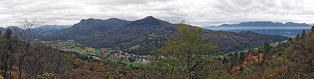
Italiano: Vista panoramica sulla Valtravaglia dal belvedere antistante la Chiesa di San Martino (Montegrino Valtravaglia). Al centro della foto, domina il Monte Pian Nave. |
||
| Date | |||
| Source |
Own work
|
||
| Author | Kaitu |

.jpg&action=edit§ion=1)
| Camera location | | View this and other nearby images on: OpenStreetMap |
|---|
.jpg¶ms=045.971179_N_0008.764135_E_globe:Earth_type:camera_heading:233.73&language=en)
This image was created with Hugin.
Licensing
edit.jpg&action=edit§ion=2)
I, the copyright holder of this work, hereby publish it under the following license:
This file is licensed under the Creative Commons Attribution 4.0 International license.
- You are free:
- to share – to copy, distribute and transmit the work
- to remix – to adapt the work
- Under the following conditions:
- attribution – You must give appropriate credit, provide a link to the license, and indicate if changes were made. You may do so in any reasonable manner, but not in any way that suggests the licensor endorses you or your use.
| Annotations | This image is annotated: View the annotations at Commons |
.jpg)
File history
Click on a date/time to view the file as it appeared at that time.
| Date/Time | Thumbnail | Dimensions | User | Comment | |
|---|---|---|---|---|---|
| current | 10:06, 3 November 2023 | 8,565 × 2,165 (10.69 MB) | Kaitu (talk | contribs) | Uploaded own work with UploadWizard |
You cannot overwrite this file.
File usage on Commons
The following 2 pages use this file:
.jpg&oldid=869797237)