File:Panoramic view near Mys Derrey - panoramio (1).jpg

Size of this preview: 800 × 140 pixels. Other resolutions: 320 × 56 pixels | 640 × 112 pixels | 1,024 × 179 pixels | 1,280 × 223 pixels | 2,560 × 447 pixels | 16,927 × 2,953 pixels.
Original file (16,927 × 2,953 pixels, file size: 22.02 MB, MIME type: image/jpeg)
Captions
Captions
Add a one-line explanation of what this file represents
Summary
edit.jpg&action=edit§ion=1)
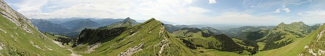
| Description | Panoramic view near Mys Derrey | ||
| Date | Taken on 10 August 2014 | ||
| Source | https://web.archive.org/web/20161103021758/http://www.panoramio.com/photo/110341032 | ||
| Author | Björn S. | ||
| Permission (Reusing this file) |
This file is licensed under the Creative Commons Attribution-Share Alike 3.0 Unported license. Attribution: Björn S.
|
||
| Tags (from Panoramio photo page) | Haut-Intyamon, Dent de Lys |
| Camera location | | View this and other nearby images on: OpenStreetMap |
|---|
.jpg¶ms=046.506307_N_0007.000699_E_globe:Earth_type:camera_source:Panoramio_&language=en)

|
The categories of this image need checking. You can do so here.
|
.jpg&action=edit&withJS=MediaWiki:Catcheck.js)
File history
Click on a date/time to view the file as it appeared at that time.
| Date/Time | Thumbnail | Dimensions | User | Comment | |
|---|---|---|---|---|---|
| current | 08:21, 12 April 2017 | 16,927 × 2,953 (22.02 MB) | Panoramio upload bot (talk | contribs) | == {{int:filedesc}} == {{Information |description=Panoramic view near Mys Derrey |date={{Taken on|2014-08-10}} |source=http://www.panoramio.com/photo/110341032 |author=[http://www.panoramio.com/user/6004592?with_photo_id=110341032 Björn S.] |permissio... |
You cannot overwrite this file.
File usage on Commons
There are no pages that use this file.
.jpg&oldid=682056925)