File:Panoramica Pisuerga Valladolid2.jpg

Size of this preview: 800 × 335 pixels. Other resolutions: 320 × 134 pixels | 640 × 268 pixels | 1,280 × 536 pixels.
Original file (1,280 × 536 pixels, file size: 106 KB, MIME type: image/jpeg)
Captions
Captions
Add a one-line explanation of what this file represents
Summary
edit
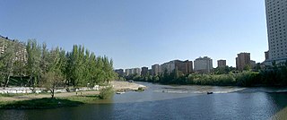
| Description | Vista del panorámica del río Pisuerga tomada desde el Puente Mayor. El barrio de la Huerta del Rey a la derecha y la playa de las Moreras a la izquierda |
| Date | |
| Source | Huerta del Rey y playa de las Moreras |
| Author | Ángel |
| Camera location | | View this and other nearby images on: OpenStreetMap |
|---|
Licensing
edit
This file is licensed under the Creative Commons Attribution 2.0 Generic license.
- You are free:
- to share – to copy, distribute and transmit the work
- to remix – to adapt the work
- Under the following conditions:
- attribution – You must give appropriate credit, provide a link to the license, and indicate if changes were made. You may do so in any reasonable manner, but not in any way that suggests the licensor endorses you or your use.
| This image was originally posted to Flickr by angeldp at https://www.flickr.com/photos/8871696@N04/2197797040. It was reviewed on 17 February 2008 by FlickreviewR and was confirmed to be licensed under the terms of the cc-by-2.0. |
File history
Click on a date/time to view the file as it appeared at that time.
| Date/Time | Thumbnail | Dimensions | User | Comment | |
|---|---|---|---|---|---|
| current | 17:17, 17 February 2008 | | 1,280 × 536 (106 KB) | Queninosta (talk | contribs) | {{Information |Description= Vista del panorámica del río Pisuerga tomada desde el Puente Mayor. El barrio de la Huerta del Rey a la derecha y la playa de las Moreras a la izquierda |Source=[http://www.flickr.com/photos/8871696@N04/2197797040/ Huerta del |
You cannot overwrite this file.
File usage on Commons
There are no pages that use this file.
File usage on other wikis
The following other wikis use this file:
- Usage on en.wikipedia.org
- Usage on es.wikipedia.org