File:Papua New Guinea earthquake January 22 2009.gif
No higher resolution available.
Papua_New_Guinea_earthquake_January_22_2009.gif (411 × 385 pixels, file size: 84 KB, MIME type: image/gif)
Captions
Captions
Add a one-line explanation of what this file represents
Summary edit
| Description |
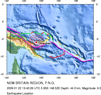
English: Location map for Earthquake Magnitude 6.0 NEW BRITAIN REGION Thursday, January 22, 2009 at 13:40:26 UTC. See [[:wikinews:Wikinews Shorts: January 23, 2009#Strong earthquakes in Indian and Pacific Oceans|]] |
| Date | |
| Source | http://neic.usgs.gov/neis/bulletin/neic_cdbi_cy.gif at http://neic.usgs.gov/neis/bulletin/neic_cdbi_l.html |
| Author | US Geological Survey |
Licensing edit
This image is in the public domain in the United States because it only contains materials that originally came from the United States Geological Survey, an agency of the United States Department of the Interior. For more information, see the official USGS copyright policy.
|
File history
Click on a date/time to view the file as it appeared at that time.
| Date/Time | Thumbnail | Dimensions | User | Comment | |
|---|---|---|---|---|---|
| current | 10:59, 23 January 2009 | | 411 × 385 (84 KB) | InfantGorilla (talk | contribs) | |
| 10:57, 23 January 2009 |  | 418 × 280 (68 KB) | InfantGorilla (talk | contribs) | {{Information |Description={{en|1=Location map for Earthquake Magnitude 6.0 NEW BRITAIN REGION Thursday, January 22, 2009 at 13:40:26 UTC. See wikinews:Wikinews Shorts: January 23, 2009#Strong earthquakes in Indian and Pacific Oceans}} |Source=http: |
You cannot overwrite this file.
File usage on Commons
There are no pages that use this file.
File usage on other wikis
The following other wikis use this file:
- Usage on en.wikinews.org