File:Parcs de Côte d'Ivoire.svg

Size of this PNG preview of this SVG file: 586 × 599 pixels. Other resolutions: 235 × 240 pixels | 469 × 480 pixels | 751 × 768 pixels | 1,001 × 1,024 pixels | 2,003 × 2,048 pixels | 843 × 862 pixels.
Original file (SVG file, nominally 843 × 862 pixels, file size: 1.79 MB)
Captions
Captions
Add a one-line explanation of what this file represents
Summary
edit| Description |
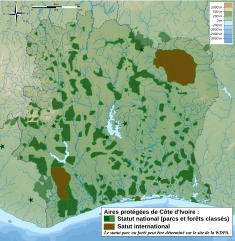
Français : Carte des parcs nationaux et internationaux de Côte d'Ivoire. Le relief et les rivières sont un fond bitmap incorporé au SVG.
English: Map of national/international parks of Côte d'Ivoire. |
| Date | |
| Source | derivative workfrom my own work : File:Côte d'Ivoire topographic map-fr.svg ; pour les zones protégées : [1]. Carte à jour en février 2009 (site wdpa)/up to date on feb 2009. Le statut parc ou forêt peut être déterminé sur le site de la WDPA. |
| Author | Bourrichon |
| Other versions | Image:Côte d'Ivoire topographic map-fr.svg |
| SVG development | {| cellspacing="8" cellpadding="0" style="clear:both; width:100%; margin:0.5em auto; border:2px solid var(--border-color-interactive, #88A); background-color:var(--background-color-neutral-subtle, #F7F8FF); color: inherit;" lang="en" dir="ltr"
|align="center"| |

Licensing
edit
I, the copyright holder of this work, hereby publish it under the following licenses:

|
Permission is granted to copy, distribute and/or modify this document under the terms of the GNU Free Documentation License, Version 1.2 or any later version published by the Free Software Foundation; with no Invariant Sections, no Front-Cover Texts, and no Back-Cover Texts. A copy of the license is included in the section entitled GNU Free Documentation License. |
This file is licensed under the Creative Commons Attribution-Share Alike 3.0 Unported, 2.5 Generic, 2.0 Generic and 1.0 Generic license.
- You are free:
- to share – to copy, distribute and transmit the work
- to remix – to adapt the work
- Under the following conditions:
- attribution – You must give appropriate credit, provide a link to the license, and indicate if changes were made. You may do so in any reasonable manner, but not in any way that suggests the licensor endorses you or your use.
- share alike – If you remix, transform, or build upon the material, you must distribute your contributions under the same or compatible license as the original.
You may select the license of your choice.
| Annotations | This image is annotated: View the annotations at Commons |
File history
Click on a date/time to view the file as it appeared at that time.
| Date/Time | Thumbnail | Dimensions | User | Comment | |
|---|---|---|---|---|---|
| current | 21:51, 1 March 2009 | | 843 × 862 (1.79 MB) | Bourrichon (talk | contribs) | Changement légende + diverses améliorations |
| 15:18, 20 February 2009 |  | 843 × 862 (1.81 MB) | Bourrichon (talk | contribs) | {{Information |Description={{fr|1=Carte des parcs nationaux et internationaux de fr:Côte d'Ivoire}} {{en|1=Map of national/international parks of Côte d'Ivoire}} |Source=Derivative work from my own work : [[:File:Côte d'Ivoire topographic map-fr. |
You cannot overwrite this file.
File usage on Commons
The following 3 pages use this file:
File usage on other wikis
The following other wikis use this file:
- Usage on de.wikipedia.org
- Usage on eo.wikipedia.org
- Usage on fr.wikipedia.org
- Usage on sw.wikipedia.org