File:Paris - Enceinte gallo-romaine.svg

Size of this PNG preview of this SVG file: 800 × 549 pixels. Other resolutions: 320 × 220 pixels | 640 × 439 pixels | 1,024 × 703 pixels | 1,280 × 878 pixels | 2,560 × 1,757 pixels | 2,120 × 1,455 pixels.
Original file (SVG file, nominally 2,120 × 1,455 pixels, file size: 1.5 MB)
Captions
Captions
Add a one-line explanation of what this file represents
Summary edit
| Description |
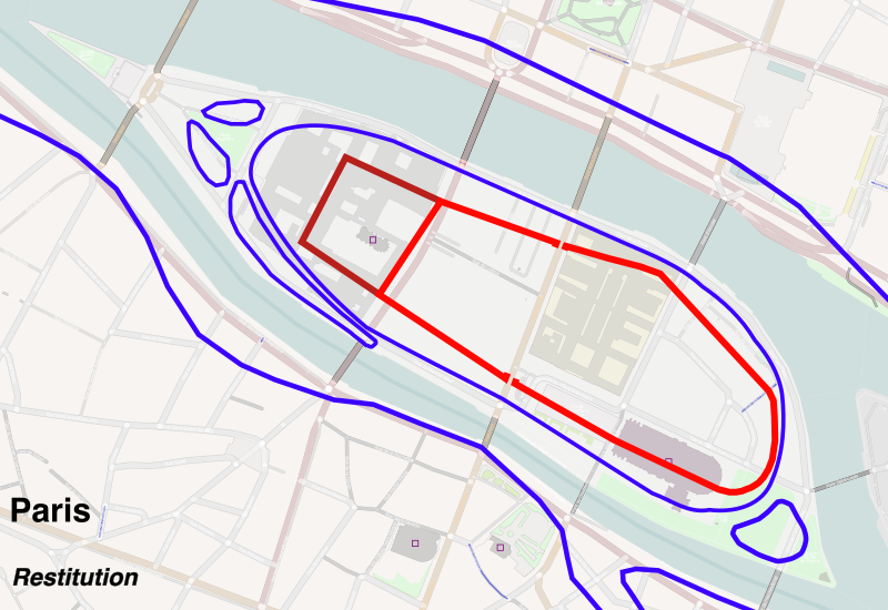
English: Gallo-roman city wall of Paris, 4th century. Map from OpenStreetMap, track description from books hereafter
Français : Restitution de l'enceinte gallo-romaine de Paris au IVe siècle |
| Date | |
| Source | Own work (d'après OpenStreetMap) |
| Author | Starus |
La carte de l'île de la Cité provient d'OpenStreetMap
Description tracé in :
- Sur les traces des enceintes de Paris, Renaud Gagneux et Denis Prouvost, éd. Parigramme, 2004
- Atlas de Paris, Danielle Chadlych et Dominique Leborgne, éd. Parigramme, 2007
Légende :
- Trait bleu : rives de la Seine
- Trait rouge : enceinte gallo-romaine
- Trait rouge foncé : palais romain
Licensing edit
I, the copyright holder of this work, hereby publish it under the following licenses:

|
Permission is granted to copy, distribute and/or modify this document under the terms of the GNU Free Documentation License, Version 1.2 or any later version published by the Free Software Foundation; with no Invariant Sections, no Front-Cover Texts, and no Back-Cover Texts. A copy of the license is included in the section entitled GNU Free Documentation License. |
This file is licensed under the Creative Commons Attribution-Share Alike 3.0 Unported, 2.5 Generic, 2.0 Generic and 1.0 Generic license.
- You are free:
- to share – to copy, distribute and transmit the work
- to remix – to adapt the work
- Under the following conditions:
- attribution – You must give appropriate credit, provide a link to the license, and indicate if changes were made. You may do so in any reasonable manner, but not in any way that suggests the licensor endorses you or your use.
- share alike – If you remix, transform, or build upon the material, you must distribute your contributions under the same or compatible license as the original.
You may select the license of your choice.
File history
Click on a date/time to view the file as it appeared at that time.
| Date/Time | Thumbnail | Dimensions | User | Comment | |
|---|---|---|---|---|---|
| current | 09:45, 17 February 2015 | | 2,120 × 1,455 (1.5 MB) | Paris 16 (talk | contribs) | cropped |
| 21:05, 19 August 2014 |  | 2,853 × 1,872 (5.2 MB) | Loup Solitaire 81 (talk | contribs) | Reverted to version as of 14:07, 4 April 2011 | |
| 19:52, 22 September 2012 |  | 2,853 × 1,872 (5.2 MB) | Nnemo (talk | contribs) | Notamment — Typographie. Chiffres romains, quand même. | |
| 14:07, 4 April 2011 |  | 2,853 × 1,872 (5.2 MB) | Starus (talk | contribs) | {{Information |Description ={{en|1=Gallo-roman city wall of Paris, 4th century. Map from OpenStreetMap, track description from books below }} {{fr|1=Restitution de l'enceinte gallo-romaine de Paris au 4e siècle}} |Source ={{own}} (d'après Ope |
You cannot overwrite this file.
File usage on Commons
The following 2 pages use this file:
File usage on other wikis
The following other wikis use this file:
- Usage on en.wikipedia.org
- Usage on es.wikipedia.org
- Usage on fr.wikipedia.org
- Usage on hy.wikipedia.org
- Usage on it.wikipedia.org
- Usage on ja.wikipedia.org
- Usage on ru.wikipedia.org
- Usage on uk.wikipedia.org