File:Partition-plan-Flahaut-nl.svg

Size of this PNG preview of this SVG file: 426 × 599 pixels. Other resolutions: 171 × 240 pixels | 341 × 480 pixels | 546 × 768 pixels | 728 × 1,024 pixels | 1,456 × 2,048 pixels.
Original file (SVG file, nominally 426 × 599 pixels, file size: 312 KB)
Captions
Captions
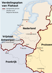
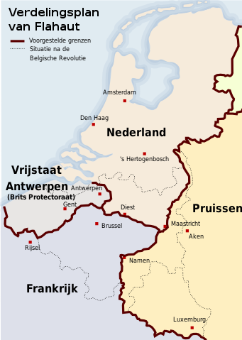
Map of a partitioning of the Southern Netherlands proposed by Flahaut after the Belgian Revolution of 1830
Summary
edit
| Description |
English: Map of a partitioning of the Southern Netherlands proposed by Flahaut after the Belgian Revolution of 1830 |
| Date | |
| Source | Own work |
| Author | Hans Erren |
Licensing
edit
I, the copyright holder of this work, hereby publish it under the following license:
This file is licensed under the Creative Commons Attribution-Share Alike 4.0 International license.
- You are free:
- to share – to copy, distribute and transmit the work
- to remix – to adapt the work
- Under the following conditions:
- attribution – You must give appropriate credit, provide a link to the license, and indicate if changes were made. You may do so in any reasonable manner, but not in any way that suggests the licensor endorses you or your use.
- share alike – If you remix, transform, or build upon the material, you must distribute your contributions under the same or compatible license as the original.
File history
Click on a date/time to view the file as it appeared at that time.
| Date/Time | Thumbnail | Dimensions | User | Comment | |
|---|---|---|---|---|---|
| current | 18:23, 11 July 2021 | | 426 × 599 (312 KB) | Hans Erren (talk | contribs) | Uploaded own work with UploadWizard |
You cannot overwrite this file.
File usage on Commons
The following 2 pages use this file:
File usage on other wikis
The following other wikis use this file:
- Usage on nl.wikipedia.org