File:Path on Mangerton Mountain - geograph.org.uk - 448599.jpg
No higher resolution available.
Path_on_Mangerton_Mountain_-_geograph.org.uk_-_448599.jpg (640 × 427 pixels, file size: 109 KB, MIME type: image/jpeg)
Captions
Captions
Add a one-line explanation of what this file represents
Summary
edit
| Description |
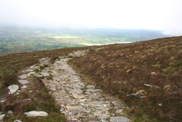
English: Path on Mangerton Mountain The path ascending Mangerton Mountain (An Mhangarta) from Gortagullane turns westwards in this gridsquare to contour around the summit through boulder-strewn rough grass. This view shows the plain around Killarney (Cill Airne) with a lough visible on the right, as the cloud base descends, at an elevation of around 570m |
| Date | |
| Source | From geograph.org.uk |
| Author | Espresso Addict |
| Attribution (required by the license) | Espresso Addict / Path on Mangerton Mountain / |
| Camera location | | View this and other nearby images on: OpenStreetMap |
|---|
_heading:45.00&language=en)
| Object location | | View this and other nearby images on: OpenStreetMap |
|---|
_heading:45.00&language=en)
Licensing
edit

|
This image was taken from the Geograph project collection. See this photograph's page on the Geograph website for the photographer's contact details. The copyright on this image is owned by Espresso Addict and is licensed for reuse under the Creative Commons Attribution-ShareAlike 2.0 license.
|
This file is licensed under the Creative Commons Attribution-Share Alike 2.0 Generic license.
Attribution: Espresso Addict
- You are free:
- to share – to copy, distribute and transmit the work
- to remix – to adapt the work
- Under the following conditions:
- attribution – You must give appropriate credit, provide a link to the license, and indicate if changes were made. You may do so in any reasonable manner, but not in any way that suggests the licensor endorses you or your use.
- share alike – If you remix, transform, or build upon the material, you must distribute your contributions under the same or compatible license as the original.
File history
Click on a date/time to view the file as it appeared at that time.
| Date/Time | Thumbnail | Dimensions | User | Comment | |
|---|---|---|---|---|---|
| current | 12:09, 4 February 2011 | | 640 × 427 (109 KB) | GeographBot (talk | contribs) | == {{int:filedesc}} == {{Information |description={{en|1=Path on Mangerton Mountain The path ascending Mangerton Mountain (An Mhangarta) from Gortagullane turns westwards in this gridsquare to contour around the summit through boulder-strewn rough grass. |
You cannot overwrite this file.
File usage on Commons
There are no pages that use this file.