File:Path to West Burton - geograph.org.uk - 891336.jpg
No higher resolution available.
Path_to_West_Burton_-_geograph.org.uk_-_891336.jpg (640 × 480 pixels, file size: 87 KB, MIME type: image/jpeg)
Captions
Captions
Add a one-line explanation of what this file represents
Summary
edit
| Description |
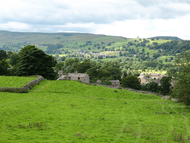
English: Path to West Burton The footpath to the village can be seen heading along the wallside towards the barn. This pasture shows evidence of old plough strips which run up and down the slope rather than contouring. Both scales of OS map fail to show this section of path between the barn and Barrack Wood - odd! |
| Date | |
| Source | From geograph.org.uk |
| Author | Gordon Hatton |
| Attribution (required by the license) | Gordon Hatton / Path to West Burton / |
| Camera location | | View this and other nearby images on: OpenStreetMap |
|---|
_heading:270.00&language=en)
| Object location | | View this and other nearby images on: OpenStreetMap |
|---|
_heading:270.00&language=en)
Licensing
edit

|
This image was taken from the Geograph project collection. See this photograph's page on the Geograph website for the photographer's contact details. The copyright on this image is owned by Gordon Hatton and is licensed for reuse under the Creative Commons Attribution-ShareAlike 2.0 license.
|
This file is licensed under the Creative Commons Attribution-Share Alike 2.0 Generic license.
Attribution: Gordon Hatton
- You are free:
- to share – to copy, distribute and transmit the work
- to remix – to adapt the work
- Under the following conditions:
- attribution – You must give appropriate credit, provide a link to the license, and indicate if changes were made. You may do so in any reasonable manner, but not in any way that suggests the licensor endorses you or your use.
- share alike – If you remix, transform, or build upon the material, you must distribute your contributions under the same or compatible license as the original.

|
The categories of this image need checking. You can do so here.
|
File history
Click on a date/time to view the file as it appeared at that time.
| Date/Time | Thumbnail | Dimensions | User | Comment | |
|---|---|---|---|---|---|
| current | 16:48, 21 February 2011 | | 640 × 480 (87 KB) | GeographBot (talk | contribs) | == {{int:filedesc}} == {{Information |description={{en|1=Path to West Burton The footpath to the village can be seen heading along the wallside towards the barn. This pasture shows evidence of old plough strips which run up and down the slope rather than |
You cannot overwrite this file.
File usage on Commons
There are no pages that use this file.