File:Pe det malh.JPG

Size of this preview: 800 × 600 pixels. Other resolutions: 320 × 240 pixels | 640 × 480 pixels | 1,024 × 768 pixels | 1,280 × 960 pixels | 2,048 × 1,536 pixels.
Original file (2,048 × 1,536 pixels, file size: 775 KB, MIME type: image/jpeg)
Captions
Captions
Add a one-line explanation of what this file represents
Summary edit
| Camera location | | View this and other nearby images on: OpenStreetMap |
|---|
| Description |
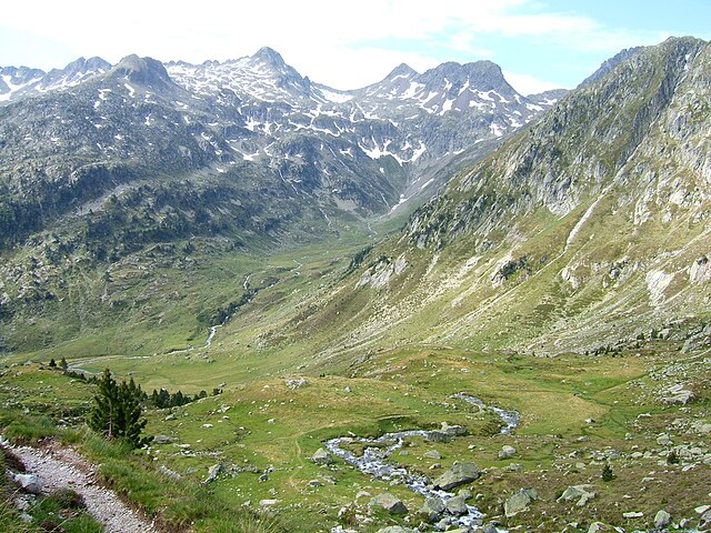
Français : Au Pé-dét-Malh, un bras du gave de Cambalès à l'avant-plan, le ruisseau du port du Marcadau dans le lointain. De droite à gauche : les pics Jumeaux, le pic de l'Affron, le grand pic de Péterneille, la pointe de la Muga et une partie du pic Arraillous English: In Pé-dét-Malh with an arm of the river Cambales and the stream of Marcadau in the background. From right to left: the Pics Jumeaux ("Twin Peaks"), the great peak of Péterneille, the point of Muga and part of peak Arraillous |
| Date | |
| Source | Own work |
| Author | Babylas |
Licensing edit
I, the copyright holder of this work, hereby publish it under the following licenses:

|
Permission is granted to copy, distribute and/or modify this document under the terms of the GNU Free Documentation License, Version 1.2 or any later version published by the Free Software Foundation; with no Invariant Sections, no Front-Cover Texts, and no Back-Cover Texts. A copy of the license is included in the section entitled GNU Free Documentation License. |
This file is licensed under the Creative Commons Attribution-Share Alike 3.0 Unported, 2.5 Generic, 2.0 Generic and 1.0 Generic license.
- You are free:
- to share – to copy, distribute and transmit the work
- to remix – to adapt the work
- Under the following conditions:
- attribution – You must give appropriate credit, provide a link to the license, and indicate if changes were made. You may do so in any reasonable manner, but not in any way that suggests the licensor endorses you or your use.
- share alike – If you remix, transform, or build upon the material, you must distribute your contributions under the same or compatible license as the original.
You may select the license of your choice.
File history
Click on a date/time to view the file as it appeared at that time.
| Date/Time | Thumbnail | Dimensions | User | Comment | |
|---|---|---|---|---|---|
| current | 19:37, 2 April 2009 | | 2,048 × 1,536 (775 KB) | Babylas (talk | contribs) | {{Information |Description={{fr|1=Au Pé-dét-Malh, un bras du gave de Cambalès à l'avant-plan, le ruisseau du port du Marcadau dans le lointain. De droite à gauche : les pics Jumeaux, le pic de l'Affron, le grand pic de Péterneille, la pointe de la M |
You cannot overwrite this file.
File usage on Commons
The following page uses this file:
File usage on other wikis
The following other wikis use this file:
- Usage on fr.wikipedia.org