File:Penelakut.png

Size of this preview: 800 × 527 pixels. Other resolutions: 320 × 211 pixels | 640 × 422 pixels | 1,024 × 675 pixels | 1,280 × 844 pixels | 1,814 × 1,196 pixels.
Original file (1,814 × 1,196 pixels, file size: 4.06 MB, MIME type: image/png)
Captions
Captions
Add a one-line explanation of what this file represents
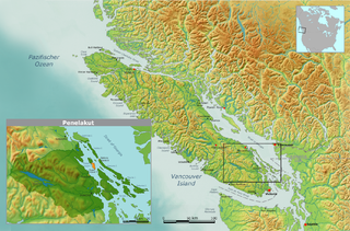
| Description | Map of traditional Penelakut tribal territory. | ||||
| Date | |||||
| Source | Own work by Nikater, submitted to the public domain. Background map courtesy of Demis, www.demis.nl | ||||
| Author | User:Nikater | ||||
| Permission (Reusing this file) |
|
File history
Click on a date/time to view the file as it appeared at that time.
| Date/Time | Thumbnail | Dimensions | User | Comment | |
|---|---|---|---|---|---|
| current | 08:25, 26 November 2007 | | 1,814 × 1,196 (4.06 MB) | Nikater (talk | contribs) | {{Information |Description=Map of traditional Penelakut tribal territory. |Source=Own work by Nikater, submitted to the public domain. Background map courtesy of Demis, www.demis.nl |Date=26 November 2007 |Author=User:Nikater |Permission={{PD-Demis}} |
You cannot overwrite this file.
File usage on Commons
There are no pages that use this file.
File usage on other wikis
The following other wikis use this file:
- Usage on de.wikipedia.org
- Usage on en.wikipedia.org
- Usage on es.wikipedia.org
- Usage on zh.wikipedia.org