File:PenobscotExpedition1779.jpg
Size of this preview: 622 × 600 pixels. Other resolutions: 249 × 240 pixels | 498 × 480 pixels | 796 × 768 pixels | 1,062 × 1,024 pixels | 2,124 × 2,048 pixels | 3,588 × 3,460 pixels.
Original file (3,588 × 3,460 pixels, file size: 5.89 MB, MIME type: image/jpeg)
Captions
Captions
Add a one-line explanation of what this file represents
Summary edit
| Description |
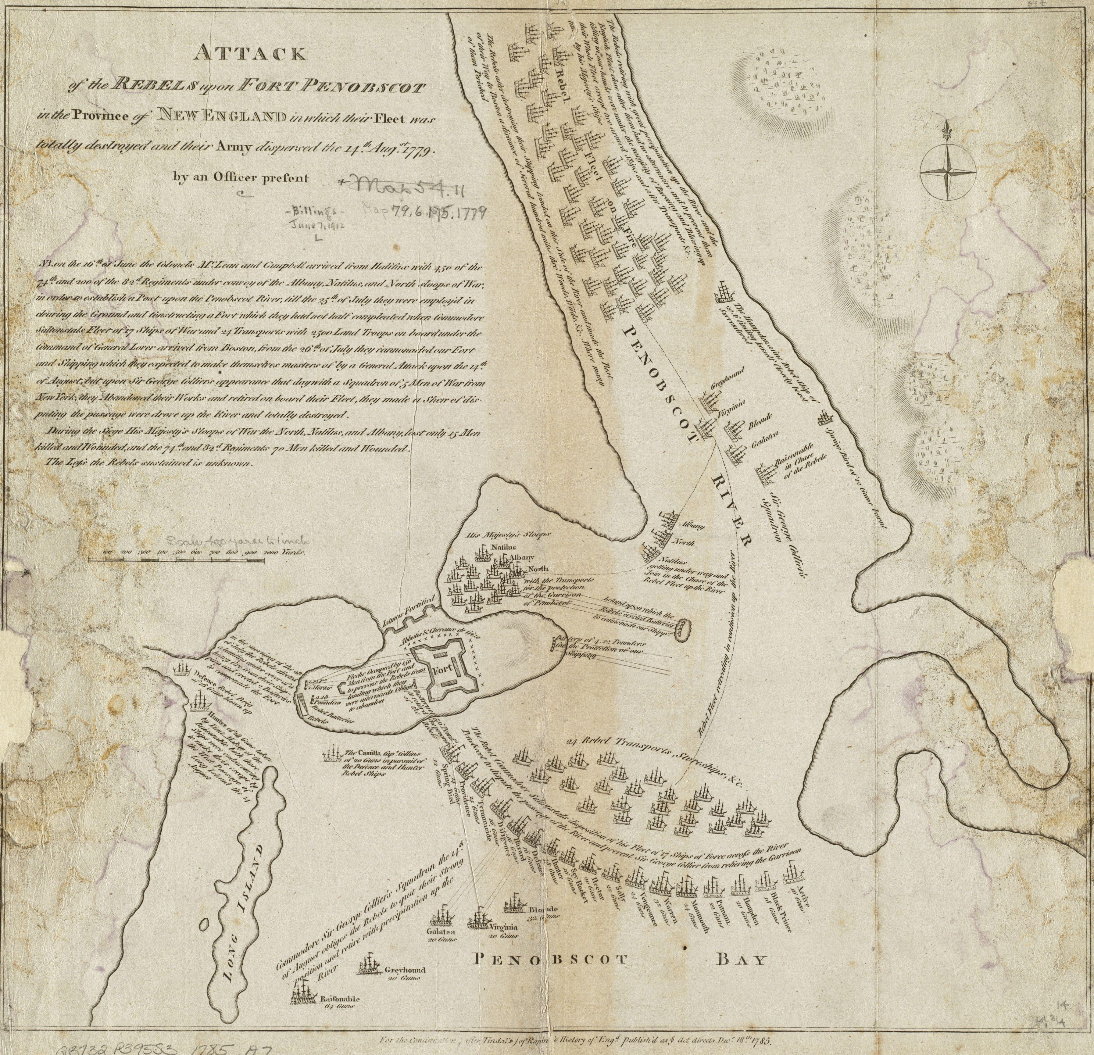
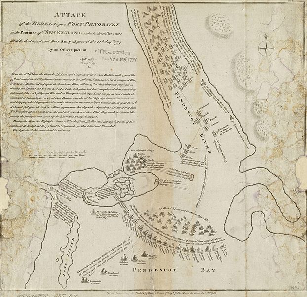
English: This 1785 map depicts the 1779 naval action of the Penobscot Expedition. The original map measures 36.0x38.0 cm. The map is in mirror image to the actual geography; the Penobscot River is actually to the peninsula's west.
The caption reads: "Attack of the rebels upon Fort Penobscot in the province of New England in which their fleet was totally destroyed and their Army dispersed the 14th Augst. 1779" |
| Date | |
| Source |
This map is from the Norman B. Leventhal Map Center at the Boston Public Library. Url at the time of upload: http://maps.bpl.org/details_10803/ Call Number: G3732.P395S3 1785 .A7 |
| Author | Unknown author |
Licensing edit
This media file is in the public domain in the United States. This applies to U.S. works where the copyright has expired, often because its first publication occurred prior to January 1, 1929, and if not then due to lack of notice or renewal. See this page for further explanation.
|
 | |
 |
This image might not be in the public domain outside of the United States; this especially applies in the countries and areas that do not apply the rule of the shorter term for US works, such as Canada, Mainland China (not Hong Kong or Macao), Germany, Mexico, and Switzerland. The creator and year of publication are essential information and must be provided. See Wikipedia:Public domain and Wikipedia:Copyrights for more details.
|
File history
Click on a date/time to view the file as it appeared at that time.
| Date/Time | Thumbnail | Dimensions | User | Comment | |
|---|---|---|---|---|---|
| current | 14:50, 8 April 2009 | | 3,588 × 3,460 (5.89 MB) | Magicpiano (talk | contribs) | Full resolution image (same source), rotated and cropped. |
| 20:44, 9 January 2009 |  | 906 × 906 (608 KB) | Magicpiano (talk | contribs) | Original, now rotated and cropped. | |
| 19:59, 9 January 2009 |  | 927 × 1,024 (844 KB) | Magicpiano (talk | contribs) | {{Information |Description={{en|1=This is a 1785 map depicting the 1779 naval action of the en:Penobscot Expedition. The original map measures 36.0x38.0cm. The caption reads: Attack of the rebels upon Fort Penobscot in the province of New England in |
You cannot overwrite this file.
File usage on Commons
There are no pages that use this file.
File usage on other wikis
The following other wikis use this file:
- Usage on en.wikipedia.org
- Usage on fr.wikipedia.org
- Usage on it.wikipedia.org
- Usage on ja.wikipedia.org
- Usage on ru.wikipedia.org