File:Percorso della Freccia del Gran Sasso.svg

Size of this PNG preview of this SVG file: 634 × 600 pixels. Other resolutions: 254 × 240 pixels | 507 × 480 pixels | 812 × 768 pixels | 1,082 × 1,024 pixels | 2,165 × 2,048 pixels | 779 × 737 pixels.
Original file (SVG file, nominally 779 × 737 pixels, file size: 21.18 MB)
Captions
Captions
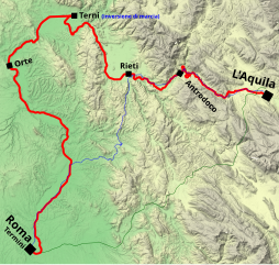
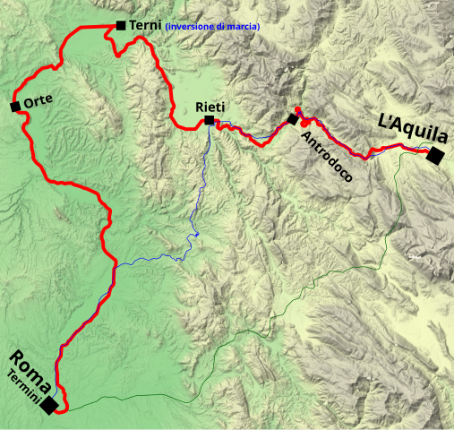
Route of the Freccia del Gran Sasso train
Summary
edit
| Description |
Italiano: Percorso del treno direttissimo "Freccia del Gran Sasso" (Roma Termini-L'Aquila), esistito dal 1959 al 1987.
Fermate intermedie effettuate in origine (successivamente furono aumentate)
Alternativa stradale nel periodo 1959-1970 (statali SS17 + SS4)
Alternativa stradale nel periodo 1970-1987 (autostrada A24) English: Route of the Freccia del Gran Sasso train (Rome-L'Aquila), which existed from 1959 to 1987. |
| Date | |
| Source | Own work |
| Author | Alessandro Antonelli |
Licensing
edit
I, the copyright holder of this work, hereby publish it under the following license:
This file is licensed under the Creative Commons Attribution 3.0 Unported license.
- You are free:
- to share – to copy, distribute and transmit the work
- to remix – to adapt the work
- Under the following conditions:
- attribution – You must give appropriate credit, provide a link to the license, and indicate if changes were made. You may do so in any reasonable manner, but not in any way that suggests the licensor endorses you or your use.
File history
Click on a date/time to view the file as it appeared at that time.
| Date/Time | Thumbnail | Dimensions | User | Comment | |
|---|---|---|---|---|---|
| current | 11:00, 12 January 2020 | | 779 × 737 (21.18 MB) | Una giornata uggiosa '94 (talk | contribs) | fix per la scritta "Roma Termini" che usciva fuori; metto in blu l'indicazione "inversione di marcia" |
| 15:51, 12 January 2019 |  | 779 × 737 (21.18 MB) | Una giornata uggiosa '94 (talk | contribs) | User created page with UploadWizard |
You cannot overwrite this file.
File usage on Commons
The following 9 pages use this file:
- User:Chumwa/OgreBot/Potential transport maps/2019 January 11-20
- User:Chumwa/OgreBot/Potential transport maps/2020 January 11-20
- User:Chumwa/OgreBot/Public transport information/2019 January 11-20
- User:Chumwa/OgreBot/Public transport information/2020 January 11-20
- User:Chumwa/OgreBot/Transport Maps/2019 January 11-20
- User:Chumwa/OgreBot/Transport Maps/2020 January 11-20
- User:Chumwa/OgreBot/Travel and communication maps/2019 January 11-20
- User:J budissin/Uploads/BiH/2019 January 11-20
- User:J budissin/Uploads/BiH/2020 January 11-20
File usage on other wikis
The following other wikis use this file:
- Usage on it.wikipedia.org
- Usage on www.wikidata.org