File:Aavasaksa topographic map-ms.svg
(Redirected from File:Peta topografi Aavasaksa.svg)

Size of this PNG preview of this SVG file: 486 × 600 pixels. Other resolutions: 194 × 240 pixels | 389 × 480 pixels | 622 × 768 pixels | 830 × 1,024 pixels | 1,660 × 2,048 pixels | 1,368 × 1,688 pixels.
Original file (SVG file, nominally 1,368 × 1,688 pixels, file size: 256 KB)
Captions
Captions
Add a one-line explanation of what this file represents
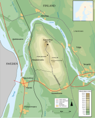
| Description |
Français : Carte topographique de la colline de Aavasaksa en Finlande
Bahasa Melayu: Peta topografi bukit Aavasaksa di Finland |
| Date | |
| Source |
Bahasa Melayu: Terbitan daripada File:Aavasaksa topographic map-fr.svg |
| Author | |
| Permission (Reusing this file) |
This file is licensed under the Creative Commons Attribution-Share Alike 3.0 Unported license.
|
| Other versions |
[]
|
| SVG development |


File history
Click on a date/time to view the file as it appeared at that time.
| Date/Time | Thumbnail | Dimensions | User | Comment | |
|---|---|---|---|---|---|
| current | 06:54, 13 December 2013 | | 1,368 × 1,688 (256 KB) | 26 Ramadan (talk | contribs) | {{Information |Description ={{fr|1=Carte topographique de la colline de Aavasaksa en Finlande}} {{ms|1=Peta topografi bukit Aavasaksa di Finland}} |Source ={{ms|1=Terbitan daripada [[:File:Aavasaksa carte topo.svg|File:Aavasaksa carte topo.s... |
You cannot overwrite this file.
File usage on Commons
The following 5 pages use this file:
File usage on other wikis
The following other wikis use this file:
- Usage on fi.wikipedia.org