File:Pfaelzerwaldkarte Flussgebiete Isenach.png

Size of this preview: 800 × 560 pixels. Other resolutions: 320 × 224 pixels | 640 × 448 pixels | 1,043 × 730 pixels.
Original file (1,043 × 730 pixels, file size: 1.02 MB, MIME type: image/png)
Captions
Captions
Add a one-line explanation of what this file represents
Summary
edit
| Description |
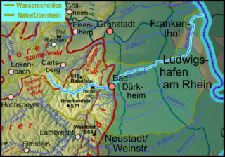
Deutsch: Flussgebietskarte der Isenach (farblich hervorgehoben) auf Basis der Flussgebietskarte zum Pfälzerwald, siehe Flussgebietskarte Pfälzer Wald |
| Date | 2011-12-10, completely new at 2012-01-18 |
| Source |
Own work
|
| Author | Elop |
| Other versions |
|
Licensing
edit

|
Permission is granted to copy, distribute and/or modify this document under the terms of the GNU Free Documentation License, Version 1.2 or any later version published by the Free Software Foundation; with no Invariant Sections, no Front-Cover Texts, and no Back-Cover Texts. A copy of the license is included in the section entitled GNU Free Documentation License. |
File history
Click on a date/time to view the file as it appeared at that time.
| Date/Time | Thumbnail | Dimensions | User | Comment | |
|---|---|---|---|---|---|
| current | 21:30, 18 January 2012 | | 1,043 × 730 (1.02 MB) | Elop (talk | contribs) | completely new |
| 01:49, 19 December 2011 |  | 1,043 × 730 (663 KB) | Elop (talk | contribs) | Update | |
| 19:51, 10 December 2011 |  | 1,053 × 688 (609 KB) | Elop (talk | contribs) | == Summary == {{Information |Description ={{de|1=Flussgebietskarte der de:Isenach (farblich hervorgehoben) auf Basis der Flussgebietskarte zum Pfälzerwald, siehe Flussgebietskarte Pfälzer Wald}} |Sou |
You cannot overwrite this file.
File usage on Commons
The following 4 pages use this file:
File usage on other wikis
The following other wikis use this file:
- Usage on de.wikipedia.org
- Usage on eo.wikipedia.org
- Usage on www.wikidata.org