File:Photocopy of drawing, typical floor beam and stringer, Bridge No. 79B, Main and Washington Sts., So. Norwalk, Ct., N. Y. Division, N.Y., N.H. and H.R.R., dated April 23, 1895. Original HAER CT-168-19.tif

Size of this JPG preview of this TIF file: 754 × 599 pixels. Other resolutions: 302 × 240 pixels | 604 × 480 pixels | 966 × 768 pixels | 1,280 × 1,018 pixels | 2,560 × 2,035 pixels | 5,445 × 4,329 pixels.
Original file (5,445 × 4,329 pixels, file size: 22.48 MB, MIME type: image/tiff)
Captions
Captions
Add a one-line explanation of what this file represents
Summary edit
| Photographer |
Related names:
|
|||
| Title |
Photocopy of drawing, typical floor beam and stringer, Bridge No. 79B, Main and Washington Sts., So. Norwalk, Ct., N. Y. Division, N.Y., N.H. and H.R.R., dated April 23, 1895. Original on file with Metro North Commuter Railroad. - South Norwalk Railroad Bridge, South Main and Washington Streets, Norwalk, Fairfield County, CT |
|||
| Depicted place | Connecticut; Fairfield County; Norwalk | |||
| Date | Documentation compiled after 1968 | |||
| Dimensions | 8 x 10 in. | |||
| Current location |
Library of Congress Prints and Photographs Division Washington, D.C. 20540 USA http://hdl.loc.gov/loc.pnp/pp.print |
|||
| Accession number |
HAER CT-168-19 |
|||
| Credit line |
|
|||
| Notes |
|
|||
| Source | https://www.loc.gov/pictures/item/ct0641.photos.205137p | |||
| Permission (Reusing this file) |
|

| Camera location | | View this and other nearby images on: OpenStreetMap |
|---|
File history
Click on a date/time to view the file as it appeared at that time.
| Date/Time | Thumbnail | Dimensions | User | Comment | |
|---|---|---|---|---|---|
| current | 22:21, 8 July 2014 | 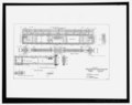 | 5,445 × 4,329 (22.48 MB) | Fæ (talk | contribs) | GWToolset: Creating mediafile for Fæ. HABS 06 July 2014 (611:700) |
You cannot overwrite this file.
File usage on Commons
The following page uses this file: