File:Pico.jpg
Size of this preview: 800 × 600 pixels. Other resolutions: 320 × 240 pixels | 640 × 480 pixels | 891 × 668 pixels.
Original file (891 × 668 pixels, file size: 65 KB, MIME type: image/jpeg)
Captions
Captions
Add a one-line explanation of what this file represents
| Description |
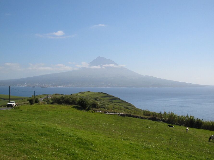
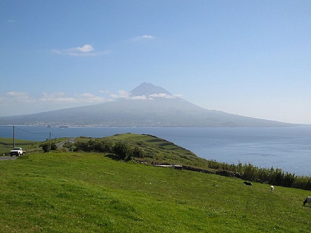
Pico, Portugal. English: Pico seen from Faial
Deutsch: Pico von Faial aus gesehen
Nederlands: Pico vanaf het naburige Faial
Español: Pico, visto desde Espalamaca, Faial.
Português: O Pico, visto da Espalamaca, Faial.
Suomi: Näkymä Picon saarelle |
| Date | 07.04.2003 |
| Source | German Wikipedia. Original text: The island of Pico, Azores, viewed lookink east from Espalamaca, east cost of Faial. The stretch of water between the islands is the Canal (Channel). The town visible in Pico is Madalena. The mountain is 2351 m high. Die Insel Pico von Faial aus gesehen. |
| Author | de:Benutzer:H Evertz (Horst Evertz) |
| Permission (Reusing this file) |
GFDL |

|
Permission is granted to copy, distribute and/or modify this document under the terms of the GNU Free Documentation License, Version 1.2 or any later version published by the Free Software Foundation; with no Invariant Sections, no Front-Cover Texts, and no Back-Cover Texts. A copy of the license is included in the section entitled GNU Free Documentation License. |
| This file is licensed under the Creative Commons Attribution-Share Alike 3.0 Unported license. | ||
| ||
| This licensing tag was added to this file as part of the GFDL licensing update. |
File history
Click on a date/time to view the file as it appeared at that time.
| Date/Time | Thumbnail | Dimensions | User | Comment | |
|---|---|---|---|---|---|
| current | 11:00, 2 July 2005 | | 891 × 668 (65 KB) | Angrense (talk | contribs) | The island of Pico, Azores, viewed lookink east from Espalamaca, west cost of Faial. The stretch of water between the island is the Canal (Channel). The town visible in Pico is Madalena. The moutain is 2351 m high. Autor: Horst Evertz (DE.wikipedia user) |
You cannot overwrite this file.
File usage on Commons
The following 2 pages use this file:
File usage on other wikis
The following other wikis use this file:
- Usage on af.wikipedia.org
- Usage on an.wikipedia.org
- Usage on arz.wikipedia.org
- Usage on ca.wikipedia.org
- Usage on ceb.wikipedia.org
- Usage on cs.wikipedia.org
- Usage on de.wikipedia.org
- Usage on de.wikivoyage.org
- Usage on el.wikipedia.org
- Usage on en.wikipedia.org
- Usage on en.wikivoyage.org
- Usage on eo.wikipedia.org
- Usage on fa.wikipedia.org
- Usage on fi.wikipedia.org
- Usage on gl.wikipedia.org
- Usage on hu.wikipedia.org
- Usage on ja.wikipedia.org
- Usage on kk.wikipedia.org
- Usage on lmo.wikipedia.org
- Usage on lt.wikipedia.org
- Usage on mn.wikipedia.org
- Usage on mwl.wikipedia.org
- Usage on nl.wikipedia.org
- Usage on nn.wikipedia.org
- Usage on no.wikipedia.org
- Usage on pl.wikipedia.org
- Usage on pt.wikipedia.org
- Ilha do Faial
- Predefinição:Info/Montanha
- Predefinição:Info/Montanha/doc
- Predefinição:Info/Cordilheira
- Predefinição:Info/Cordilheira/doc
- Wikipédia:Wiki Loves Açores
- Predefinição:Info/Montanha/Testes
- Predefinição:Info/Montanha/Exemplos para testes
- Predefinição:Info/Montanha2
- Predefinição:Info/Montanha/Wikidata
- Usage on ro.wikipedia.org
- Usage on ru.wikipedia.org
- Usage on sh.wikipedia.org
- Usage on sk.wikipedia.org
View more global usage of this file.