File:Pilica (gmina) location map.png

Original file (1,839 × 2,172 pixels, file size: 642 KB, MIME type: image/png)
Captions
Captions
Summary
edit_location_map.png&action=edit§ion=1)
| Description |
English: Location map |
| Date | |
| Source | Own work |
| Author | Smat |
| Description |
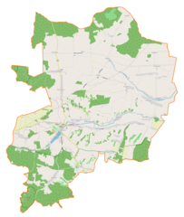
Polski: Mapa gminy Pilica, Polska
English: Map of Pilica (gmina), Poland |
|||||||||
| Date | ||||||||||
| Source | You may find a page on the OpenStreetMap wiki page for Pilica (gmina) | |||||||||
| Creator |
OpenStreetMap contributors OpenStreetMap contributors |
|||||||||
| Permission (Reusing this file) |
OpenStreetMap data is available under the Open Database License (details). Map tiles are licensed under the Creative Commons Attribution-ShareAlike 2.0 license (CC-BY-SA 2.0).
This file is licensed under the Creative Commons Attribution-Share Alike 2.0 Generic license.
|
|||||||||
| Geotemporal data | ||||||||||
| Bounding box |
|
|||||||||
| Georeferencing | If inappropriate please set warp_status = skip to hide. | |||||||||
Licensing
edit_location_map.png&action=edit§ion=2)
| This work contains information from OpenStreetMap, which is made available under the Open Database License (ODbL).
The ODbL does not require any particular license for maps produced from ODbL data. Prior to 1 August 2020, map tiles produced by the OpenStreetMap Foundation were licensed under the CC-BY-SA-2.0 license. Maps produced by other people may be subject to other licences. |
File history
Click on a date/time to view the file as it appeared at that time.
| Date/Time | Thumbnail | Dimensions | User | Comment | |
|---|---|---|---|---|---|
| current | 12:56, 17 November 2018 | | 1,839 × 2,172 (642 KB) | Smat (talk | contribs) | User created page with UploadWizard |
You cannot overwrite this file.
File usage on Commons
There are no pages that use this file.
File usage on other wikis
The following other wikis use this file:
- Usage on de.wikipedia.org
- Usage on pl.wikipedia.org
- Pilica (miasto)
- Dobra-Kolonia
- Dobraków
- Dzwonowice
- Dzwono-Sierbowice
- Kleszczowa
- Kidów
- Kocikowa
- Maleszyna
- Sierbowice
- Solca
- Sławniów
- Wierbka
- Złożeniec
- Cisowa (województwo śląskie)
- Dobra (województwo śląskie)
- Jasieniec (województwo śląskie)
- Podleśna (województwo śląskie)
- Przychody (województwo śląskie)
- Siadcza (województwo śląskie)
- Smoleń (województwo śląskie)
- Szyce (województwo śląskie)
- Biskupice (powiat zawierciański)
- Zarzecze (powiat zawierciański)
- Wierzbica (województwo śląskie)
- Rezerwat przyrody Smoleń
- Zamek w Smoleniu
- Jaskinia na Biśniku
- Parafia Najświętszego Imienia Jezus w Pilicy
- Parafia św. Jana Chrzciciela i św. Jana Ewangelisty w Pilicy
- Rezerwat przyrody Ruskie Góry
- Parafia Najświętszego Serca Pana Jezusa w Dzwono-Sierbowicach
- Zamek w Pilicy
- Cmentarz wojenny w Biskupicach
- Klasztor oo. franciszkanów w Pilicy
- Przykopy (województwo śląskie)
- Polska (województwo śląskie)
- Pałac Moesów w Wierbce
- Bukowa Góra (Smoleń)
- Kościół św. Jana Chrzciciela i św. Jana Ewangelisty w Pilicy
- Kościół św. Jerzego w Pilicy
- Moduł:Mapa/dane/Pilica (gmina)
- Moduł:Mapa/dane/Pilica (województwo śląskie)
- Parafia Matki Bożej Częstochowskiej w Dobrakowie
- Parafia św. Mikołaja w Kidowie
- Parafia Niepokalanego Poczęcia Najświętszej Maryi Panny w Wierbce
- Tunel w Górze Smoleń
- Oczko (schronisko)
- Schronisko przy Ziemi
View more global usage of this file.
_location_map.png)
_location_map.png&oldid=706465058)