File:Pind-Meglen.png
No higher resolution available.
Pind-Meglen.png (200 × 204 pixels, file size: 23 KB, MIME type: image/png)
Captions
Captions
Add a one-line explanation of what this file represents
Summary edit
| Description |
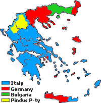
Approximative area (yellow) proposed by Alcibiades Diamandi for an eventual puppet-state called "Principality of the Pindus" in northern Greece under Italian occupation (this name was initially used in 1917 for another similar italian project). Diamandi's attempt of statehood had neither definite territory nor any borders, and never came close to realization; the yellow area in this map is likely to cover the maximalist area of the "Principality". |
| Source | Own work, since a hand-drawn boundary (1942 or 1943) surimposed on a map of the Aromanians areas in Balkans, found & seen in the library of the Military Museum of Bucharest. |
| Author | Spiridon MANOLIU |
Licensing edit
| This file is made available under the Creative Commons CC0 1.0 Universal Public Domain Dedication. | |
| The person who associated a work with this deed has dedicated the work to the public domain by waiving all of their rights to the work worldwide under copyright law, including all related and neighboring rights, to the extent allowed by law. You can copy, modify, distribute and perform the work, even for commercial purposes, all without asking permission.
|
File history
Click on a date/time to view the file as it appeared at that time.
| Date/Time | Thumbnail | Dimensions | User | Comment | |
|---|---|---|---|---|---|
| current | 17:39, 3 May 2010 | | 200 × 204 (23 KB) | Spiridon Ion Cepleanu (talk | contribs) | {{Information |Description={{ro|1=Principatul de Pind si Meglen, 1941-1943}} |Source={{own}} |Author=Spiridon MANOLIU |Date= |Permission= |other_versions= }} Category:Maps of Greece |
You cannot overwrite this file.
File usage on Commons
There are no pages that use this file.
File usage on other wikis
The following other wikis use this file:
- Usage on cs.wikipedia.org
- Usage on en.wikipedia.org
- Usage on fa.wikipedia.org
- Usage on it.wikipedia.org
- Usage on ka.wikipedia.org
- Usage on lv.wikipedia.org
- Usage on sq.wikipedia.org
- Usage on zh.wikipedia.org