File:Pinilla-Soler, 1907.png

Size of this preview: 448 × 600 pixels. Other resolutions: 179 × 240 pixels | 358 × 480 pixels | 574 × 768 pixels | 765 × 1,024 pixels | 1,464 × 1,960 pixels.
Original file (1,464 × 1,960 pixels, file size: 284 KB, MIME type: image/png)
Captions
Captions
Add a one-line explanation of what this file represents
Summary edit
| Description |
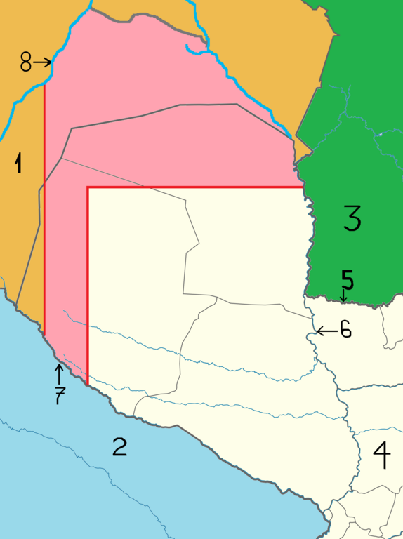
Español: Esquema de lo acordado en el Tratado limítrofe Pinilla-Soler entre Bolivia y Paraguay, del 12 de enero de 1907.
El sector en color rosa era el área a someter a un fallo arbitral. Números en el mapa: 1: Bolivia; 2: Argentina; 3: Brasil; 4: Paraguay; 5: río Apa; 6: río Paraguay; 7: río Pilcomayo; 8: río Parapetí. English: Pinilla-Soler border treaty between Bolivia and Paraguay, from January 12, 1907. The pink sector was the area to submit to an arbitration award. Numbers on the map: 1: Bolivia; 2: Argentina; 3: Brazil; 4: Paraguay; 5: river Apa; 6: Paraguay river; 7: Pilcomayo river; 8: river Parapetí. |
| Date | |
| Source | Own work |
| Author | CHUCAO |
Licensing edit
I, the copyright holder of this work, hereby publish it under the following license:
This file is licensed under the Creative Commons Attribution-Share Alike 3.0 Unported license.
- You are free:
- to share – to copy, distribute and transmit the work
- to remix – to adapt the work
- Under the following conditions:
- attribution – You must give appropriate credit, provide a link to the license, and indicate if changes were made. You may do so in any reasonable manner, but not in any way that suggests the licensor endorses you or your use.
- share alike – If you remix, transform, or build upon the material, you must distribute your contributions under the same or compatible license as the original.
File history
Click on a date/time to view the file as it appeared at that time.
| Date/Time | Thumbnail | Dimensions | User | Comment | |
|---|---|---|---|---|---|
| current | 15:21, 14 July 2012 | | 1,464 × 1,960 (284 KB) | CHUCAO (talk | contribs) |
You cannot overwrite this file.
File usage on Commons
There are no pages that use this file.
File usage on other wikis
The following other wikis use this file:
- Usage on es.wikipedia.org