File:Pinus lambertiana USGS range map 2.png
(Redirected from File:Pinus lambertiana.png)

Size of this preview: 342 × 600 pixels. Other resolutions: 137 × 240 pixels | 273 × 480 pixels | 924 × 1,621 pixels.
Original file (924 × 1,621 pixels, file size: 89 KB, MIME type: image/png)
Captions
Captions
Add a one-line explanation of what this file represents
Summary edit
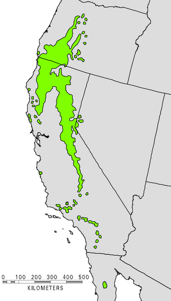
- U.S. Forestry distribution map showing the native range of the Sugar Pine (Pinus lambertiana).
- Source
[1] (pdf file)
Licensing edit
This image is in the public domain in the United States because it only contains materials that originally came from the United States Geological Survey, an agency of the United States Department of the Interior. For more information, see the official USGS copyright policy.
|
File history
Click on a date/time to view the file as it appeared at that time.
| Date/Time | Thumbnail | Dimensions | User | Comment | |
|---|---|---|---|---|---|
| current | 13:35, 7 January 2008 | | 924 × 1,621 (89 KB) | MPF (talk | contribs) | Clearer version from USGS |
| 17:44, 21 October 2006 | 374 × 1,004 (77 KB) | Wsiegmund (talk | contribs) | Re-edited image colors for clarity | ||
| 02:57, 21 October 2006 | 374 × 1,004 (246 KB) | Wsiegmund (talk | contribs) | == Summary == US Forestry map showing the native range of the Sugar Pine: http://www.na.fs.fed.us/Spfo/pubs/silvics_manual/Volume_1/pinus/lambertiana.htm == Licensing == {{PD-USGov}} |
You cannot overwrite this file.
File usage on Commons
The following 4 pages use this file:
File usage on other wikis
The following other wikis use this file:
- Usage on arz.wikipedia.org
- Usage on ast.wikipedia.org
- Usage on cs.wikipedia.org
- Usage on el.wikipedia.org
- Usage on es.wikipedia.org
- Usage on et.wikipedia.org
- Usage on fa.wikipedia.org
- Usage on fr.wikipedia.org
- Usage on it.wikipedia.org
- Usage on nl.wikipedia.org
- Usage on pl.wikipedia.org
- Usage on pt.wikipedia.org
- Usage on ru.wikipedia.org
- Usage on vi.wikipedia.org
- Usage on www.wikidata.org