File:Pipelines in Eastern Europe.png
No higher resolution available.
Pipelines_in_Eastern_Europe.png (643 × 474 pixels, file size: 71 KB, MIME type: image/png)
Captions
Captions
Add a one-line explanation of what this file represents
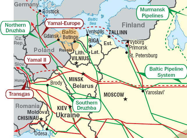
Pipelines in Eastern Europe. Red: gas pipelines. Green: oil pipelines. Dashed: planned pipelines. Brown: prospective region.
Cropped from http://www.eia.doe.gov/emeu/cabs/Russia/images/fsu_energymap.pdf See [1] for context.
| This image is a work of a United States Department of Energy (or predecessor organization) employee, taken or made as part of that person's official duties. As a work of the U.S. federal government, the image is in the public domain.
Please note that national laboratories operate under varying licences and some are not free. Check the site policies of any national lab before crediting it with this tag.
|

|
File history
Click on a date/time to view the file as it appeared at that time.
| Date/Time | Thumbnail | Dimensions | User | Comment | |
|---|---|---|---|---|---|
| current | 19:04, 2 June 2011 | | 643 × 474 (71 KB) | Ras67 (talk | contribs) | cropped |
| 09:01, 30 June 2010 |  | 654 × 483 (89 KB) | Ds02006 (talk | contribs) | Corrected the border between Romania and the Ukraine | |
| 22:26, 9 January 2007 |  | 654 × 483 (50 KB) | Conscious (talk | contribs) | +border | |
| 22:17, 9 January 2007 |  | 654 × 483 (51 KB) | Conscious (talk | contribs) | Pipelines in Eastern Europe. Red: gas pipelines. Green: oil pipelines. Dashed: planned pipelines. Brown: prospective region. Cropped from http://www.eia.doe.gov/emeu/cabs/Russia/images/fsu_energymap.pdf {{PD-US-DoE}} Category:Maps of Europe |
You cannot overwrite this file.
File usage on Commons
The following page uses this file:
File usage on other wikis
The following other wikis use this file:
- Usage on ar.wikipedia.org
- Usage on az.wikipedia.org
- Usage on be-tarask.wikipedia.org
- Usage on be.wikipedia.org
- Usage on bg.wikipedia.org
- Usage on de.wikipedia.org
- Usage on en.wikipedia.org
- Usage on fi.wikipedia.org
- Usage on fr.wikipedia.org
- Usage on hy.wikipedia.org
- Usage on it.wikipedia.org
- Usage on ko.wikipedia.org
- Usage on nl.wikipedia.org
- Usage on pl.wikipedia.org
- Usage on pt.wikipedia.org
- Usage on ru.wikipedia.org
- Usage on ru.wikinews.org
- Usage on uk.wikipedia.org
- Нафтопровід Одеса — Броди
- Дружба (нафтопровід)
- Магістральний нафтопровід
- Балтійська трубопровідна система
- Транспорт України
- Користувач:Alex Blokha/Дні згадані в Вікіпедії/Україна/10 жовтня
- Користувач:Alex Blokha/Дні згадані в Вікіпедії/Україна/13 жовтня
- Користувач:Alex Blokha/Дні згадані в Вікіпедії/Україна/15 жовтня
- Користувач:Alex Blokha/Дні згадані в Вікіпедії/Україна/4 листопада
- Користувач:Alex Blokha/Дні згадані в Вікіпедії/Україна/10 грудня
- Користувач:Alex Blokha/Дні згадані в Вікіпедії/Україна/12 грудня
- Користувач:Alex Blokha/Дні згадані в Вікіпедії/Україна/18 грудня
- Користувач:Alex Blokha/Дні згадані в Вікіпедії/Україна/19 грудня
- Користувач:Alex Blokha/Дні згадані в Вікіпедії/Україна/26 грудня
- Користувач:Alex Blokha/Дні згадані в Вікіпедії/Україна/28 січня
- Користувач:Alex Blokha/Дні згадані в Вікіпедії/Україна/6 лютого
- Користувач:Alex Blokha/Дні згадані в Вікіпедії/Україна/13 лютого
- Користувач:Alex Blokha/Дні згадані в Вікіпедії/Україна/19 квітня
- Користувач:Alex Blokha/Дні згадані в Вікіпедії/Україна/29 квітня
- Користувач:Alex Blokha/Дні згадані в Вікіпедії/Україна/23 червня
View more global usage of this file.