File:Piz Bernina Panorama.jpg

Size of this preview: 800 × 125 pixels. Other resolutions: 320 × 50 pixels | 640 × 100 pixels | 1,024 × 160 pixels | 1,280 × 200 pixels | 2,560 × 400 pixels | 26,624 × 4,163 pixels.
Original file (26,624 × 4,163 pixels, file size: 12.44 MB, MIME type: image/jpeg)
Captions
Captions
Add a one-line explanation of what this file represents
| Warning | The original file is very high-resolution. It might not load properly or could cause your browser to freeze when opened at full size. |
|---|
Summary edit
| Description |
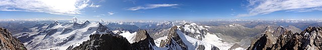
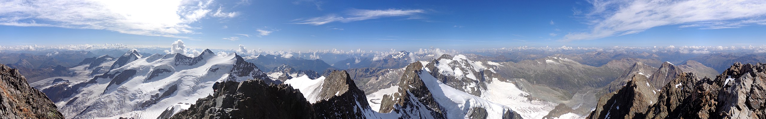
English: 360° panorama from Piz Bernina (Samedan / Pontresina, Grisons, Switzerland)
Deutsch: 360°-Panorama vom Piz Bernina (Samedan / Pontresina, Graubünden, Schweiz)
Rumantsch: Vista panoramica da 360° digl Piz Bernina (Samedan / Pontresina, Grischun, Svizra)
Italiano: Vista panoramica di 360° dal Piz Bernina (Samedan / Pontresina, Grigioni, Svizzera) |
||
| Date | |||
| Source |
Own work
|
||
| Author | Capricorn4049 | ||
| Permission (Reusing this file) |
|
||
| Other versions |
|


| Camera location | | View this and other nearby images on: OpenStreetMap |
|---|
| 360° | View in 360° panoramic viewer
|
|---|
| Warning | The original file is very high-resolution. It might not load properly or could cause your browser to freeze when opened at full size. |
|---|
|
|
Further panoramas can be found here. |
Licensing edit
I, the copyright holder of this work, hereby publish it under the following license:
This file is licensed under the Creative Commons Attribution-Share Alike 4.0 International license.
- You are free:
- to share – to copy, distribute and transmit the work
- to remix – to adapt the work
- Under the following conditions:
- attribution – You must give appropriate credit, provide a link to the license, and indicate if changes were made. You may do so in any reasonable manner, but not in any way that suggests the licensor endorses you or your use.
- share alike – If you remix, transform, or build upon the material, you must distribute your contributions under the same or compatible license as the original.
File history
Click on a date/time to view the file as it appeared at that time.
| Date/Time | Thumbnail | Dimensions | User | Comment | |
|---|---|---|---|---|---|
| current | 04:29, 23 August 2020 | 26,624 × 4,163 (12.44 MB) | Capricorn4049 (talk | contribs) | Uploaded own work with UploadWizard |
You cannot overwrite this file.
File usage on Commons
The following 3 pages use this file: