File:Plan Centre Spatial Guyanais-fr.svg

Size of this PNG preview of this SVG file: 648 × 599 pixels. Other resolutions: 260 × 240 pixels | 519 × 480 pixels | 831 × 768 pixels | 1,108 × 1,024 pixels | 2,215 × 2,048 pixels | 1,060 × 980 pixels.
Original file (SVG file, nominally 1,060 × 980 pixels, file size: 600 KB)
Captions
Captions
Add a one-line explanation of what this file represents

|
This SVG file contains embedded text that can be translated into your language, using any capable SVG editor, text editor or the SVG Translate tool. For more information see: About translating SVG files. |
Summary
edit| Description |
[]
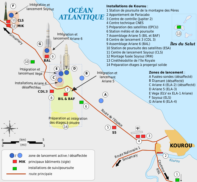
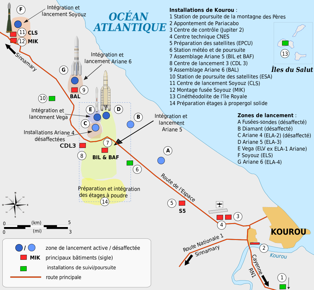
Català: Mapa de la infraestructura dels llançadors Ariane i Vega al port espacial europeu (Centre Spatial Guyanais o CSG), Kourou, Guaiana Francesa Deutsch: Karte der Infrastruktur der Ariana- und Vega-Startrampen auf dem Weltraumbahnhof Kourou, Französisch-Guayana English: Map of the infrastructure for the Ariane and Vega launchers at the Europe's Spaceport (Centre Spatial Guyanais or CSG) , Kourou, French Guiana Français : Carte des installations du Centre Spatial Guyanais (CSG) de Kourou, Guyane Francaise (France) Magyar: A Guyanai Űrközpont térképe Nederlands: Kaart van de Europese lanceerbasis (Centre Spatial Guyanais of CSG) in Kourou, Frans Guiana Русский: План космодрома «Куру» во Французской Гвиане |
||
| Date | |||
| Source | Own work | ||
| Author | Pline | ||
| Other versions |
[]
|


Licensing
edit
I, the copyright holder of this work, hereby publish it under the following licenses:

|
Permission is granted to copy, distribute and/or modify this document under the terms of the GNU Free Documentation License, Version 1.2 or any later version published by the Free Software Foundation; with no Invariant Sections, no Front-Cover Texts, and no Back-Cover Texts. A copy of the license is included in the section entitled GNU Free Documentation License. |
This file is licensed under the Creative Commons Attribution-Share Alike 3.0 Unported, 2.5 Generic, 2.0 Generic and 1.0 Generic license.
- You are free:
- to share – to copy, distribute and transmit the work
- to remix – to adapt the work
- Under the following conditions:
- attribution – You must give appropriate credit, provide a link to the license, and indicate if changes were made. You may do so in any reasonable manner, but not in any way that suggests the licensor endorses you or your use.
- share alike – If you remix, transform, or build upon the material, you must distribute your contributions under the same or compatible license as the original.
You may select the license of your choice.
File history
Click on a date/time to view the file as it appeared at that time.
| Date/Time | Thumbnail | Dimensions | User | Comment | |
|---|---|---|---|---|---|
| current | 11:10, 31 January 2022 | | 1,060 × 980 (600 KB) | Pline (talk | contribs) | petites corrections |
| 08:50, 29 January 2022 |  | 1,060 × 980 (598 KB) | Pline (talk | contribs) | mise en forme | |
| 08:42, 29 January 2022 |  | 1,060 × 980 (598 KB) | Pline (talk | contribs) | compléments | |
| 10:38, 28 January 2022 |  | 1,060 × 980 (596 KB) | Pline (talk | contribs) | Mise en forme | |
| 10:17, 28 January 2022 |  | 1,060 × 980 (589 KB) | Pline (talk | contribs) | ajout centre de lancement 3, modif couleur zone de lancement | |
| 11:05, 27 January 2022 |  | 1,060 × 980 (669 KB) | Pline (talk | contribs) | Ajout complexe de lancement ELA 4 (Ariane 6) | |
| 13:51, 13 April 2009 |  | 1,060 × 980 (524 KB) | Pline (talk | contribs) | corrections mineures | |
| 22:23, 15 February 2009 |  | 1,060 × 980 (524 KB) | Pline (talk | contribs) | Petites corrections graphiques | |
| 22:11, 15 February 2009 |  | 1,060 × 980 (524 KB) | Pline (talk | contribs) | {{Information |Description={{en|1=Map of the infrastructure for the Ariane and Vega launchers at the Europe's Spaceport (Centre Spatial Guyanais or CSG) , Kourou, French Guiana}} {{fr|1=Carte des installations du Centre Spatial Guyanais (CSG) de Kourou, G |
You cannot overwrite this file.
File usage on Commons
The following 10 pages use this file:
- Centre Spatial Guyanais
- User:Magog the Ogre/Multilingual legend/2022 January 21-31
- File:Plan Centre Spatial Guyanais-ca.svg
- File:Plan Centre Spatial Guyanais-de.svg
- File:Plan Centre Spatial Guyanais-en.svg
- File:Plan Centre Spatial Guyanais-fr.svg
- File:Plan Centre Spatial Guyanais-hu.svg
- File:Plan Centre Spatial Guyanais-nl.svg
- File:Plan Centre Spatial Guyanais-ru.svg
- Template:Other versions/Plan Centre Spatial Guyanais
File usage on other wikis
The following other wikis use this file:
- Usage on ca.wikinews.org
- Usage on en.wikipedia.org
- Usage on fr.wikipedia.org
- Usage on fr.wikibooks.org
- Usage on fr.wikinews.org
- Usage on gcr.wikipedia.org