File:Plan Fliegerhorst Lipperbruch.png

Size of this preview: 622 × 600 pixels. Other resolutions: 249 × 240 pixels | 498 × 480 pixels | 797 × 768 pixels | 1,062 × 1,024 pixels | 2,124 × 2,048 pixels | 2,835 × 2,733 pixels.
Original file (2,835 × 2,733 pixels, file size: 3.42 MB, MIME type: image/png)
Captions
Captions
Add a one-line explanation of what this file represents
Summary edit
| Description |
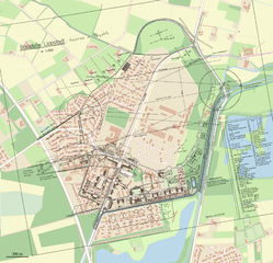
Deutsch: Fliegerhorst Lipperbruch, Bebauungsplan von 1938 über OpenStreetMap, Stand: Januar 2017
English: Lippstadt Airfield |
| Date | |
| Source |
Own work using:
|
| Author | NordNordWest |

|
This map has been made or improved in the German Kartenwerkstatt (Map Lab). You can propose maps to improve as well.
|
Licensing edit
I, the copyright holder of this work, hereby publish it under the following license:
This file is licensed under the Creative Commons Attribution-Share Alike 2.0 Generic license.
- You are free:
- to share – to copy, distribute and transmit the work
- to remix – to adapt the work
- Under the following conditions:
- attribution – You must give appropriate credit, provide a link to the license, and indicate if changes were made. You may do so in any reasonable manner, but not in any way that suggests the licensor endorses you or your use.
- share alike – If you remix, transform, or build upon the material, you must distribute your contributions under the same or compatible license as the original.
File history
Click on a date/time to view the file as it appeared at that time.
| Date/Time | Thumbnail | Dimensions | User | Comment | |
|---|---|---|---|---|---|
| current | 16:55, 24 January 2017 | | 2,835 × 2,733 (3.42 MB) | NordNordWest (talk | contribs) | == {{int:filedesc}} == {{Information |description= {{de|1=Fliegerhorst Lipperbruch, Bebauungsplan von 1938 über OpenStreetMap, Stand: Januar 2017}} {{en|1=Lippstadt Airfield}} |source={{Own using}} * [http://www.openstreetmap.org/ OpenStreetMap] data... |
You cannot overwrite this file.
File usage on Commons
The following page uses this file:
File usage on other wikis
The following other wikis use this file:
- Usage on de.wikipedia.org
- Usage on en.wikipedia.org