File:Plan Hannoversche Klippen.png

Size of this preview: 800 × 574 pixels. Other resolutions: 320 × 229 pixels | 640 × 459 pixels | 1,024 × 734 pixels | 1,280 × 918 pixels | 2,560 × 1,835 pixels | 2,975 × 2,133 pixels.
Original file (2,975 × 2,133 pixels, file size: 924 KB, MIME type: image/png)
Captions
Captions
Add a one-line explanation of what this file represents
Summary
edit
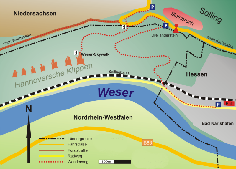
| Description | Lageplan der "Hannoverschen Klippen" bei Bad Karlshafen an der Weser am Dreiländereck Hessen, Niedersachsen, Nordrhein-Westfalen |
| Date | |
| Source | Own work |
| Author | Presse03 (talk) |
Licensing
edit
I, the copyright holder of this work, hereby publish it under the following licenses:

|
Permission is granted to copy, distribute and/or modify this document under the terms of the GNU Free Documentation License, Version 1.2 or any later version published by the Free Software Foundation; with no Invariant Sections, no Front-Cover Texts, and no Back-Cover Texts. A copy of the license is included in the section entitled GNU Free Documentation License. |
This file is licensed under the Creative Commons Attribution-Share Alike 3.0 Unported, 2.5 Generic, 2.0 Generic and 1.0 Generic license.
- You are free:
- to share – to copy, distribute and transmit the work
- to remix – to adapt the work
- Under the following conditions:
- attribution – You must give appropriate credit, provide a link to the license, and indicate if changes were made. You may do so in any reasonable manner, but not in any way that suggests the licensor endorses you or your use.
- share alike – If you remix, transform, or build upon the material, you must distribute your contributions under the same or compatible license as the original.
You may select the license of your choice.
File history
Click on a date/time to view the file as it appeared at that time.
| Date/Time | Thumbnail | Dimensions | User | Comment | |
|---|---|---|---|---|---|
| current | 16:39, 4 June 2012 | | 2,975 × 2,133 (924 KB) | Gerold Rosenberg (talk | contribs) | - Rand entfernt - Transparenz nach weiss gewechselt (Transparenz macht bei dieser Grafik keinen Sinn) - Landesgrenze bis 1837 entfernt (übersichtlicher und für Plan nicht wichtig) - Schriftzug Presse30 entfernt |
| 23:16, 20 August 2011 |  | 3,089 × 2,247 (872 KB) | Presse03 (talk | contribs) | {{Information |Description=Lageplan der "Hannoverschen Klippen" bei Bad Karlshafen an der Weser am Dreiländereck Hessen, Niedersachsen, Nordrhein-Westfalen |Source=own work |Date=2011-08-17 |Author=~~~ |Permission= |other_versions= }} [[Category:Hannover |
You cannot overwrite this file.
File usage on Commons
There are no pages that use this file.
File usage on other wikis
The following other wikis use this file:
- Usage on de.wikipedia.org
- Usage on nl.wikipedia.org