File:Plan La Rochelle et environs, 1773, Nicolas Chalmandrier, BNF Gallica.jpg

Original file (8,564 × 6,128 pixels, file size: 43.38 MB, MIME type: image/jpeg)
Captions
Captions
| Warning | The original file is very high-resolution. It might not load properly or could cause your browser to freeze when opened at full size. |
|---|
Summary edit
| Description |
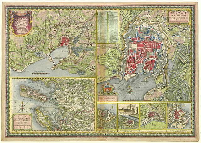
Français : Plan de La Rochelle et de ses environs lors du siège de 1627-1628, carte de l'Aunis et de La Rochelle en 1773, vue de certaines fortifications de villes de l'Aunis. English: Map of the city of La Rochelle and surroundings during the Siege in 1627-28, and in 1773, Map of the Aunis province, and views of some fortifications of cities of Aunis. |
||||
| Date | 1773. 2013-06-16 for upload | ||||
| Source |
Bibliothèque nationale de France |
||||
| Creator |
Nicolas Chalmandrier. Upload, stitch and restoration by Jebulon |
||||
| Permission (Reusing this file) |
|
||||
| Georeferencing | If inappropriate please set warp_status = skip to hide. |
| Camera location | | View this and other nearby images on: OpenStreetMap |
|---|
| This is a retouched picture, which means that it has been digitally altered from its original version. Modifications: Cleaning of spots, dust, dirt, tears and scratches du to age. Correction of levels (light, saturation, contrast). With GIMP.
|
|

|
This image has been assessed under the valued image criteria and is considered the most valued image on Commons within the scope: Historical maps of La Rochelle, 1773 engraving. You can see its nomination here. |
Licensing edit
|
This is a faithful photographic reproduction of a two-dimensional, public domain work of art. The work of art itself is in the public domain for the following reason:
The official position taken by the Wikimedia Foundation is that "faithful reproductions of two-dimensional public domain works of art are public domain".
This photographic reproduction is therefore also considered to be in the public domain in the United States. In other jurisdictions, re-use of this content may be restricted; see Reuse of PD-Art photographs for details. | ||||
File history
Click on a date/time to view the file as it appeared at that time.
| Date/Time | Thumbnail | Dimensions | User | Comment | |
|---|---|---|---|---|---|
| current | 17:51, 16 June 2013 | | 8,564 × 6,128 (43.38 MB) | Jebulon (talk | contribs) | restored |
| 17:13, 16 June 2013 |  | 8,564 × 6,128 (34.89 MB) | Jebulon (talk | contribs) | User created page with UploadWizard |
You cannot overwrite this file.
File usage on Commons
The following 19 pages use this file:
- User:Husky/POTY 2013 gallery
- User:Jebulon/Images de valeur
- User:Jebulon/Images remarquables
- User:Miya/sandbox/FP/2013/Galleries/Table
- User:Ö/Best/2013
- Commons:Featured picture candidates/File:Plan La Rochelle et environs, 1773, Nicolas Chalmandrier, BNF Gallica.jpg
- Commons:Featured picture candidates/Log/June 2013
- Commons:Featured pictures/Non-photographic media/Maps
- Commons:Featured pictures/chronological/2013-A
- Commons:Picture of the Year/2013/Candidates
- Commons:Picture of the Year/2013/Galleries/Table
- Commons:Picture of the Year/2013/R1/Gallery/2013-A
- Commons:Picture of the Year/2013/R1/Gallery/ALL
- Commons:Picture of the Year/2013/R1/Gallery/M06
- Commons:Picture of the Year/2013/R1/Gallery/Maps
- Commons:Picture of the Year/2013/R1/Results/Candidates
- Commons:Picture of the Year/2013/R1/v/Plan La Rochelle et environs, 1773, Nicolas Chalmandrier, BNF Gallica.jpg
- Commons:Valued image candidates/Plan La Rochelle et environs, 1773, Nicolas Chalmandrier, BNF Gallica.jpg
- Commons:Valued images by topic/Historical/Documents
File usage on other wikis
The following other wikis use this file:
- Usage on es.wikipedia.org
- Usage on fa.wikipedia.org
- Usage on fr.wikipedia.org
- Usage on mg.wikipedia.org
- Usage on nl.wikipedia.org
- Usage on uk.wikipedia.org
- Usage on vi.wikipedia.org
- Usage on www.wikidata.org